The Special Region of Yogyakarta (Indonesian: Daerah Istimewa Yogyakarta, or DIY), is a province of Indonesia on the island of Java. It is the only province in Indonesia that is still formally governed by a precolonial Sultanate, the Sultanate of Ngayogyakarta Hadiningrat. Yogyakarta is commonly pronounced and often spelled Jogjakarta (IPA /ʤogʤəkartə/).
The city of Yogyakarta is the capital of the province.
•
Geography
Yogyakarta is located in south-central Java. It is surrounded by the province of Central Java (Jawa Tengah) and the Indian Ocean in the south. The city is located at 7°47′S, 110°22′E.
The population of DIY in 2003 was approximately 3,000,000. The province of Yogyakarta has a total area of 3,185.80 km². Yogyakarta has the second-smallest area of the provinces in Indonesia, after the Jakarta Capital Region. However it has, along with adjacent areas in Central Java, some of the highest population densities of Java.
Administrative divisions
Yogyakarta province is subdivided into four regencies (kabupaten) and one city (kota):
• Bantul Regency (506.86 km²)
• Gunung Kidul Regency (1,485.36 km²)
• Kulon Progo Regency (586.27 km²)
• Sleman Regency (574.82 km²)
• Yogyakarta City (32.5 km²)
Yogyakarta city
Main article: Yogyakarta (city)
Located within the Yogyakarta province, Yogyakarta city is known as a center of classical Javanese fine art and culture such as batik, ballet, drama, music, poetry and puppet shows. It is also famous as a center for Indonesian higher education. At Yogyakarta's center is the kraton, or Sultan's palace. While the city sprawls in all directions from the kraton, the core of the modern city is to the north.
History
The Yogyakarta Sultanate, formally the Sultanate of Ngayogyakarta Hadiningrat, was formed in 1755 when the existing Sultanate of Mataram was divided by the Dutch East India Company (VOC) in two under the Treaty of Giyanti. This treaty states that the Sultanate of Mataram was to be divided into the Sultanate of Ngayogyakarta Hadiningrat with Yogyakarta as the capital and Mangkubumi who became Sultan Hamengkubuwono I as its Sultan and the Sultanate of Surakarta Hadiningrat with Surakarta as the capital and Pakubuwono III who was the ruler of the Sultanate of Mataram as its Sultan. The Sultan Hamengkubuwono I spent the next 37 years building the new capital, with the Kraton as the centerpiece and the court at Surakarta as the blueprint model. By the time he died in 1792, his territory exceeded Surakarta's.
The ruler Sri Sultan Hamengkubuwono IX (April 12, 1912 - 1988) held a degree from the Dutch Leiden University, and held for a time the largely ceremonial position of Vice-President of Indonesia, in recognition of his status, as well as Minister of Finance and Minister of Defense.
In support of Indonesia declaring independence from the Dutch and Japanese occupation, in September 5, 1945, Sri Sultan Hamengkubuwono IX of Yogya and Sri Paku Alam VIII in Yogya declared their sultanates to be part of the Republic of Indonesia. In return for this unfailing support, a law was passed in 1950, in which Yogyakarta was granted the status of province Daerah Istimewa (Special Region Province), with special status that recognizes the power of the Sultan in his own region's domestic affairs. Hence Sultan Hamengkubuwono IX was appointed as the governor for life. During the Indonesian war of independence against the Dutch after World War II (1945-1950), the capital of the newly-declared Indonesian republic was temporarily moved to Yogyakarta when the Dutch reoccupied Jakarta from January 1946 until August 1950.
The current ruler of Yogyakarta is his son, Sri Sultan Hamengkubuwono X, who holds a law degree from Universitas Gadjah Mada. Upon the elder sultan's death, the position of governor, according to the agreement with Indonesia, was to pass to his heir. However, the central government at that time insisted on an election. In 1998, Sultan Hamengkubuwono X was elected as governor by the provincial house of representatives (DPRD) of Yogyakarta, defying the will of the central government. He remains the only governor in Java without a military background: "I may be a sultan," he has been quoted in Asia Week as saying, "but is it not possible for me to also be a democrat?" [1]
See also List of Governors of Yogyakarta See also Yogyakarta Sultanate
2006 Earthquake
Main article: May 2006 Java earthquake
The province of Yogyakarta bore the brunt of a 6.3-magnitude earthquake on 27 May 2006 which killed 5,782 people and left some 36,299 persons injured. More than 135,000 houses are damaged, and 600,000 people are homeless [2]. The earthquake extensively damaged the local region of Bantul, and its surrounding hinterland. The most significant number of deaths occurred in this region.
The coincidence of the recent eruption of Mount Merapi, and the earthquake would not be lost on the older and more superstitious Javanese - as such natural phenonomena are given considerable import within their understanding of the spiritual aspect of such events.
Transportation
Yogyakarta is served by Adisucipto International Airport.
Sister relationships
Yogyakarta has signed a sister relationship agreement with Kyoto Prefecture, Japan,[3] and California, United States.[4]
See also
• List of Governors of Yogyakarta
• Universitas Gadjah Mada
• Mbah Maridjan
References
1. ^ (2003) Indonesia's Population: Ethnicity and Religion in a Changing Political Landscape. Institute of Southeast Asian Studies.
2. ^ "Indonesia lowers quake death toll", CNN, 2006-06-06. Retrieved on 2006-06-06.
3. ^ Kyoto prefecture List of Friendly and Sister City
4. ^ BILL NUMBER: SCR 23 CHAPTERED
5. From Wikipedia, the free encyclopedia
• Department of Tourism, Post and Telecommunication Regional Office For Yogyakarta Special Region. (1997) Guide To Yogyakarta. Yogyakarta: Department of Tourism, Post and Telecommunication.
• Ricklefs, M.C. (2001) A history of modern Indonesia since c.1200 (3rd ed.). Stanford: Stanford University Press. pp. 126-139, 269-271. ISBN 0-8047-4480-7
Further reading
• Ricklefs, M.C. (1974) Jogjakarta under Sultan Mangkubumi, 1749–1792: A history of the division of Java . London Oriental Series, vol. 30. London : Oxford University Press, (Revised Indonesian edition 2002)
• Soemanto, Bakdi (1992) Cerita Rakyat dari Yogyakarta Jakarta: Grasindo (In Indonesian)
• Soemardjan, S. (1962) Social Changes in Yogyakarta, Ithaca, N.Y. Cornelll University Press.
External links
• Official website
• Yogyakarta travel guide from Wikitravel
• Paul Spencer Sochaczewski, "The Sultan and the mermaid: a love story for the ages,"International Herald Tribune: interview with Sultan Hamengkubuwono IX
Selasa, 29 Mei 2007
Senin, 28 Mei 2007
Toraja
The Toraja are an ethnic group indigenous to a mountainous region of South Sulawesi, Indonesia. Their population is approximately 650,000, of which 450,000 still live in the regency of Tana Toraja ("Land of Toraja").[1] Most of the population is Christian, and others are Muslim or have local animist beliefs known as aluk ("the way"). The Indonesian government has recognized this animist belief as Aluk To Dolo ("Way of the Ancestors").
The word toraja comes from the Bugis language's to riaja, meaning "people of the uplands". The Dutch colonial government named the people Toraja in 1909.[3] Torajans are renowned for their elaborate funeral rites, burial sites carved into rocky cliffs, massive peaked-roof traditional houses known as tongkonan, and colorful wood carvings. Toraja funeral rites are important social events, usually attended by hundreds of people and lasting for several days.
Before the 20th century, Torajans lived in autonomous villages, where they practised animism and were relatively untouched by the outside world. In the early 1900s, Dutch missionaries first worked to convert Torajan highlanders to Christianity. When the Tana Toraja regency was further opened to the outside world in the 1970s, it became an icon of tourism in Indonesia: it was exploited by tourism developers and studied by anthropologists.[4] By the 1990s, when tourism peaked, Toraja society had evolved significantly, from its agricultural beginnings—in which social life and customs were outgrowths of the Aluk To Dolo—into a largely Christian society.[5]
Ethnic identity
The Torajan people had little notion of themselves as a distinct ethnic group before the 20th century. Before Dutch colonization and Christianization, Torajans, who lived in highland areas, identified with their villages and did not share a broad sense of identity. Although complexes of rituals created linkages between highland villages, there were variations in dialects, differences in social hierarchies, and an array of ritual practices in the Sulawesi highland region. "Toraja" (from the coastal languages' to, meaning people; and riaja, uplands) was first used as a lowlander expression for highlanders.[3] As a result, "Toraja" initially had more currency with outsiders—such as the Bugis and Makassarese, who constitute a majority of the lowland of Sulawesi—than with insiders. The Dutch missionaries' presence in the highlands gave rise to the Toraja ethnic consciousness in the Sa'dan Toraja region, and this shared identity grew with the rise of tourism in the Tana Toraja Regency.[4] Since then, South Sulawesi has four main ethnic groups—the Bugis (the majority, including shipbuilders and seafarers), the Makassarese (lowland traders and seafarers), the Mandarese (traders and fishermen), and the Toraja (highland rice cultivators).[6]
Location of Toraja (green) among Makassarese (yellow) and Bugis (red) on Sulawesi island.
History
From the 17th century, the Dutch established trade and political control on Sulawesi through the Dutch East Indies Company. Over two centuries, they ignored the mountainous area in the central Sulawesi, where Torajans lived, because access was difficult and it had little productive agricultural land. In the late 19th century, the Dutch became increasingly concerned about the spread of Islam in the south of Sulawesi, especially among the Makassarese and Bugis peoples. The Dutch saw the animist highlanders as potential Christians. In the 1920s, the Reformed Missionary Alliance of the Dutch Reformed Church began missionary work aided by the Dutch colonial government.[7] In addition to introducing Christianity, the Dutch abolished slavery and imposed local taxes. A line was drawn around the Sa'dan area and called Tana Toraja ("the land of Toraja"). Tana Toraja was first a subdivision of the Luwu kingdom that had claimed the area.[8] In 1946, the Dutch granted Tana Toraja a regentschap, and it was recognized in 1957 as one of the regencies of Indonesia.[7]
Early Dutch missionaries faced strong opposition among Torajans, especially among the elite, because the abolition of their profitable slave trade had angered them.[9] Some Torajans were forcibly relocated to the lowlands by the Dutch, where they could be more easily controlled. Taxes were kept high, undermining the wealth of the elites. Ultimately, the Dutch influence did not subdue Torajan culture, and only a few Torajans were converted.[10] In 1950, only 10% of the population had converted to Christianity.[9]
In the 1930s, Muslim lowlanders attacked the Torajans, resulting in widespread Christian conversion among those who sought to align themselves with the Dutch for political protection and to form a movement against the Bugis and Makassarese Muslims. Between 1951 and 1965 (following Indonesian independence), southern Sulawesi faced a turbulent period as the Darul Islam separatist movement fought for an Islamic state in Sulawesi. The 15 years of guerrilla warfare led to massive conversions to Christianity.[11]
Alignment with the Indonesian government, however, did not guarantee safety for the Torajans. In 1965, a presidential decree required every Indonesian citizen to belong to one of five officially recognized religions: Islam, Christianity (Protestantism and Catholicism), Hinduism, or Buddhism.[12] The Torajan religious belief (aluk) was not legally recognized, and the Torajans raised their voices against the law. To make aluk accord with the law, it had to be accepted as part of one of the official religions. In 1969, Aluk To Dolo ("the way of ancestors") was legalized as a sect of Agama Hindu Dharma, the official name of Hinduism in Indonesia.[7]
Society
There are three main types of affiliation in Toraja society: family, class and religion.
Family affiliation
A Toraja village
Family is the primary social and political grouping in Torajan society. Each village is one extended family, the seat of which is the tongkonan, a traditional Torajan house. Each tongkonan has a name, which becomes the name of the village. The familial dons maintain village unity. Marriage between distant cousins (fourth cousins and beyond) is a common practice that strengthens kinship. Toraja society prohibits marriage between close cousins (up to and including the third cousin)—except for nobles, to prevent the dispersal of property.[13] Kinship is actively reciprocal, meaning that the extended family helps each other farm, share buffalo rituals, and pay off debts.
Each person belongs to both the mother's and the father's families, the only bilateral family line in Indonesia.[14] Children, therefore, inherit household affiliation from both mother and father, including land and even family debts. Children's names are given on the basis of kinship, and are usually chosen after dead relatives. Names of aunts, uncles and cousins are commonly referred to in the names of mothers, fathers and siblings.
Before the start of the formal administration of Toraja villages by the Tana Toraja Regency, each Toraja village was autonomous. In a more complex situation, in which one Toraja family could not handle their problems alone, several villages formed a group; sometimes, villages would unite against other villages. Relationship between families was expressed through blood, marriage, and shared ancestral houses (tongkonan), practically signed by the exchange of buffalo and pigs on ritual occasions. Such exchanges did not only build political and cultural ties between families, but defined each person's place in a social hierarchy: who poured palm wine, who wrapped a corpse and prepared offerings, where each person could or could not sit, what dishes should be used or avoided, and even what piece of meat constituted one's share.[15]
Class affiliation
In early Toraja society, family relationships were tied closely to social class. There were three strata: nobles, commoners, and slaves; slavery was abolished in 1909 by the Dutch East Indies government. Class was inherited through the mother. It was taboo, therefore, to marry "down" with a woman of lower class. On the other hand, marrying a woman of higher class could improve the status of the next generation.
The nobility's condescending attitude toward the commoners is still maintained for reasons of family prestige.[5] Nobles, who were believed to be direct descendants of the descended person from heaven,[16] lived in tongkonans, while commoners lived in less lavish houses (bamboo shacks called banua). Slaves lived in small huts, which had to be built around their owner's tongkonan. Commoners might marry anyone, but nobles preferred to marry in-family to maintain their status. Sometimes nobles married Bugis or Makassarese nobles. Commoners and slaves were prohibited from having death feasts. Despite close kinship and status inheritance, there was a some social mobility, as marriage or change in wealth could affect an individual's status.[13] Wealth is counted by the ownership of water buffalos, which will be slaughtered during his/her funeral feast.
Slaves in Toraja society were family property. Sometimes Torajans decided to become slaves when they had a debt, pledging to work as payment. Slaves could be owned during wars, and slave trading was common. Slaves could buy their freedom, but their children still inherited slave status. Slaves were prohibited from wearing bronze and gold, carving their houses, eating from the same dishes as their owners, or having sex with free women—a crime punishable by death.
Religious affiliation
Toraja's indigenous belief system is polytheistic animism, called aluk, or "the way" (sometimes translated as "the law"). In the Toraja myth, the ancestors of Torajan people came down from heaven using stairs, which were then used by the Torajans as a communication medium with Puang Matua, the Creator.[17] The cosmos, according to aluk, is divided into the upper world (heaven), the world of man (earth), and the underworld.[9] At first, heaven and earth were married, then there was a darkness, a separation, and finally the light. Animals live in the underworld, which is represented by rectangular space enclosed by pillars; the earth is for mankind and the heaven world is located above, covered with a saddle-shaped roof. Other Toraja gods include Pong Banggai di Rante (god of Earth), Indo' Ongon-Ongon (a goddess who can cause earthquakes), Pong Lalondong (god of death), Indo' Belo Tumbang (goddess of medicine); there are many more.[18]
The authority, whose words and actions should be taken both in life (agriculture) and death (funerals), is called to minaa (an aluk priest). Aluk is not just a belief system; it is a combination of law, religion, and habit. Aluk governs social life, agricultural practices, and ancestral rituals. The details of aluk may vary from one village to another. One common law is the requirement that death and life rituals be separated. Torajans believe that performing death rituals might ruin their corpses if combined with life rituals.[19] The two rituals are equally important. During the Dutch missionary works, Christian Torajans were prohibited from attending or performing life rituals, but were allowed to perform death rituals.[10] Consequently, Toraja's death rituals are still practiced today, while life rituals have diminished.
Culture
Tongkonan
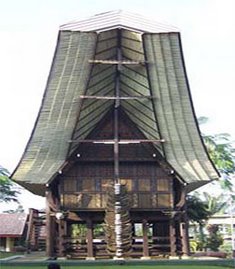
The tongkonan is the traditional Torajan house. It is an ancestral house standing high on wooden piles, covered on top with layered split bamboo roofs curving in sweeping arcs, incised with red, black, and yellow detailed wood carving ornaments at the exterior wall. The word "tongkonan" comes from the Toraja language's tongkon ("to sit").
Tongkonan is the center of Toraja social life. The rituals associated with tongkonan are important expressions of Toraja spiritual life, and therefore all family members are impelled to participate, because symbolically tongkonan represents links to their ancestors and to living and future kin.[15] According to Torajan myth, the first tongkonan was built in heaven on four poles, with a roof made of Indian cloth. When the first Torajan ancestor descended to earth, he imitated the house and held a large ceremony.[20]
The construction of a tongkonan is laborious work and is usually done with the help of the extended family. There are three types of tongkonan. The tongkonan layuk is the house of the highest authority, used as the "center of government". The tongkonan pekamberan belongs to the family members who have some authority in local traditions. Ordinary family members reside in the tongkonan batu. The exclusivity to the nobility of the tongkonan is diminishing as many Torajan commoners find lucrative employment in other parts of Indonesia. As they send back money to their families, they enable the construction of larger tongkonan.
Wood carvings
The Toraja language is only spoken; no writing system exists.[21] To express social and religious concepts, Torajans carve wood, calling it Pa'ssura (or "the writing"). Wood carvings are therefore Toraja's cultural manifestation.
Each carving receives a special name and common motifs are animals and plants that symbolize of some goodwill. For example, water plants and animals, such as crabs, tadpoles and water weeds, are commonly found to symbolize fertility. The left image shows an example of Toraja wood carving, consisting of 15 square panels. The center bottom panel represents buffalo or wealth, because they wish a lot of buffalos for their family. The center panel represents a knot and a box. It is a hope that all of their offspring will be happy and live in harmony, just like goods that are kept safe in a box. The top left and top right squares represent an aquatic animal, indicating the need for fast and hard work just like moving in the surface of water. It also represents the need for a certain skill to produce good results.
Regularity and order are common features in Toraja wood carving (see table below), as well as abstracts and geometrical designs. Nature is frequently used as the basis of Toraja's ornaments, because nature is full of abstractions and geometries with regularities and ordering.[21] Toraja's ornaments have been studied in ethnomathematics to reveal its mathematical structure, but Torajans make these arts only based on some approximations.[21] To create an ornament, bamboo sticks are used as a geometrical tool.
Funeral rites
A stone-carved burial site. Tau tau (effigies of the deceased) were put in the cave, facing down the land.
In Toraja society, the funeral ritual is the most elaborate and expensive event. The richer and more powerful an individual, the more expensive his or her funeral. In the aluk religion, only nobles have the right to have an extensive death feast.[23] The death feast of a nobleman is usually attended by thousands and lasts for several days. A ceremonial site, called rante, is usually prepared in a large area of grass field where shelters for audiences, rice barns, and other ceremonial funeral structures are specially made by the deceased family. Flute music, funeral chants, songs and poems, crying and wailing are traditional Toraja expression for grief with the exceptions of funerals for young children, and poor, low-status adults.[24]
The ceremony is often held weeks, months, or years after the death so that the deceased family can raise the significant funds needed to cover funeral expenses.[25] Torajans traditionally believe that death is not a sudden, abrupt event, but a gradual process toward Puya (the land of souls, or afterlife). During the waiting period, the body of the deceased is wrapped in several layers of cloth and kept under the tongkonan. The soul of the deceased is thought to linger around the village until the funeral ceremony is completed, after which it begins its journey to Puya.[26]
Another component of the ritual is the slaughter of water buffalo. The more powerful the person who died, the more buffalo are slaughtered at the death feast. Buffalo carcasses, including their heads, are usually lined on a field waiting for their owner, who is in the "sleeping stage". Torajans believe that the deceased will need the buffalo to make the journey, and that they will be quicker to arrive at Puya if they have many buffalo. Slaughtering tens of water buffalo and hundred of pigs using a machete becomes the peak of the elaborate death feast, along with dance, music and young boys who catch spurting blood in long bamboo tubes. Some of the slaughtered animals are given by guests as "gifts", which are carefully noted because they will be considered debts of the deceased family.[27]
There are three methods of burial: the coffin may be laid in a cave, in a carved stone grave, or hung on a cliff. It contains any possessions that the deceased will need in the afterlife. The wealthy are often buried in a stone grave carved out of the rocky cliff. The grave is usually expensive and takes a few months to complete. In some areas, a stone cave may be found that is large enough to accommodate a whole family. A wood-carved effigy, called tau tau, is usually placed in the cave facing down over the land.[28] The coffin of a deceased baby or child may be hung from ropes on a cliff face or from a tree. This hanging grave usually lasts for years, until the ropes rot and the coffin falls to the ground.
Dance and music
Torajans perform dances on several occasions, most often during their elaborate funeral ceremonies. They dance to express their grief, and to honour and even cheer the deceased person because he is going to have a long journey in the afterlife. First, a group of men form a circle and sing a monotonous chant throughout the night to honour the deceased (a ritual called Ma'badong),[27][6] and it is considered by many Torajans as the most important component of the funeral ceremony.[24] On the second funeral day, the Ma'randing warrior dance is performed to praise the courage of the deceased during life. Several men perform the dance with a sword, a large shield made from buffalo skin, a helmet with a buffalo horn, and other ornamentation. The Ma'randing dance precedes a procession in which the deceased is carried from a rice barn to the rante, the site of the funeral ceremony. During the funeral, elder women perform the Ma'katia dance while singing a poetic song and wearing a long feathered costume. The Ma'akatia dance is performed to remind the audience of the generosity and loyalty of the deceased person. After the bloody ceremony of buffalo and pig slaughter, a group of boys and girls clap their hands while performing a cheerful dance called Ma'dondan.
As in other agricultural societies, Torajans dance and sing during harvest time. The Ma'bugi dance celebrates the thanksgiving event, and the Ma'gandangi dance is performed while Torajans are pounding rice.[29] There are several war dances, such as the Manimbong dance performed by men, followed by the Ma'dandan dance performed by women. The aluk religion governs when and how Torajans dance. A dance called Ma'bua can be performed only once every 12 years. Ma'bua is a major Toraja ceremony in which priests wear a buffalo head and dance around a sacred tree.
A traditional musical instrument of the Toraja is a bamboo-made flute called Pa'suling (suling is an Indonesian word for flute). This six-holed flute (not unique to Toraja) is played at many dances, such as the thanksgiving dance Ma'bondensan, where the flute accompanies a group of shirtless, dancing men with long fingernails. Toraja has endemic musical instruments, such as the Pa'pelle (made from palm leaves) and the Pa'karombi (the Toraja version of a Jew's harp). The Pa'pelle is played during harvest time and at house inauguration ceremonies.[30]
Language
The ethnic Toraja language is dominant in Tana Toraja with the main language is the Sa'dan Toraja. Although the national Indonesian language is the official language and is spoken in the community,[1] all elementary schools in Tana Toraja teach Toraja language.
Language varieties of Toraja, including Kalumpang, Mamasa, Tae' , Talondo' , Toala' , and Toraja-Sa'dan, belong to the Malayo-Polynesian language from the Austronesian family.[31] At the outset, the isolated geographical nature of Tana Toraja formed many dialects between the Toraja languages themselves. After the formal administration of Tana Toraja, some Toraja dialects have been influenced by other languages through the transmigration program, introduced since the colonialism period, and it has been a major factor in the lingusitic variety of Toraja languages.[6]
A prominent attribute of Toraja language is the notion of grief. The importance of death ceremony in Toraja culture has characterized their languages to express intricate degrees of grief and mourning.[24] The Toraja language contains many terms referring sadness, longing, depression, and mental pain. It is a catharsis to give a clear notion about psychological and physical effect of loss, and sometimes to lessen the pain of grief itself
.
Economy
Prior to Suharto's "New Order" administration, the Torajan economy was based on agriculture, with cultivated wet rice in terraced fjords on mountain slopes, and supplemental cassava and maize crops. Much time and energy were devoted to raising water buffalo, pigs, and chickens, primarily for ceremonial sacrifices and consumption.[11] The only agricultural industry in Toraja was a Japanese coffee factory, Kopi Toraja.
With the commencement of the New Order in 1965, Indonesia's economy developed and opened to foreign investment. Multinational oil and mining companies opened new operations in Indonesia. Torajans, particularly younger ones, relocated to work for the foreign companies: to Kalimantan for timber and oil, to Papua for mining, and to the cities of Sulawesi and Java. The out-migration of Torajans was steady until 1985.[7]
The Torajan economy gradually shifted to tourism beginning in 1984. Between 1984 and 1997, many Torajans obtained their incomes from tourism, by working in hotels as tour guides or selling souvenirs. With the rise of political and economic instability in Indonesia in the late 1990s—including religious conflicts elsewhere on Sulawesi—tourism in Tana Toraja has declined dramatically.
Commercialization
A Torajan tomb in a high rocky cliff is one of the tourist attractions in Tana Toraja.
Before the 1970s, Toraja was almost unknown to Western tourism. In 1971, about 50 Europeans visited Tana Toraja. In 1972, at least 400 visitors attended the funeral ritual of Puang of Sangalla, the highest-ranking nobleman in Tana Toraja and the last pure-blood Toraja noble. The event was documented by National Geographic and broadcast in several European countries.[7] In 1976, about 12,000 tourists visited the regency and in 1981, Torajan sculpture was exhibited in major North American museums.[32] "The land of the heavenly kings of Tana Toraja", as written in the exhibition brochure, embraced the outside world.
In 1984, the Indonesian Ministry of Tourism declared Tana Toraja Regency the prima donna of South Sulawesi. Tana Toraja was heralded as "the second stop after Bali".[5] Tourism was increasing dramatically: by 1985, a total number of 150,000 foreigners had visited the Regency (in addition to 80,000 domestic tourists),[4] and the annual number of foreign visitors was recorded 40,000 in 1989.[7] Souvenir stands appeared in Rantepao, the cultural center of Toraja, roads were sealed at the most visited tourist sites, new hotels and tourist-oriented restaurants were opened, and an airstrip was opened in the Regency in 1981.[15]
Tourism developers have marketed Tana Toraja as an exotic adventure—an area rich in culture and off the beaten track. Western tourists expected to see stone-age villages and pagan funerals. Toraja is for tourists who have gone as far as Bali and are willing to see more of wild, "untouched" islands. However, they were more likely to see a Torajan wearing a hat and denim, living in a Christian society.[7] Tourists felt that the tongkonan and other Torajan rituals had been preconceived to make profits, and complained that the destination was too commercialized. This has resulted in several clashes between Torajans and tourism developers, whom Torajans see as outsiders.[4]
A clash between local Torajan leaders with the South Sulawesi provincial government (as a tourist developer) surfaced in 1985. The government designated 18 Toraja villages and burial sites as traditional tourist objects. Consequently zoning restrictions were applied for these areas, such that Torajans themselves were barred from changing their tongkonans and burial sites. The plan was opposed by some Toraja leaders, as they felt that their rituals and traditions were being determined by outsiders. As a result, in 1987, the Toraja village Kété Kesú and several other designated "tourist objects" closed their doors to tourists. This closure lasted only a few days, as the villagers found it too difficult to survive without the income from selling souvenirs.[4]
Tourism has also transformed Toraja society. Originally, there was a ritual which allowed commoners to marry nobles (puang) and thereby gain nobility for their children. However, tourist imageries have made Torajans concealing their social status. High status is not as esteemed in Tana Toraja as it once was. Many low-ranking citizens can declare themselves and their children nobles by gaining enough wealth through work outside the region, and then marrying a noble woman.[5]
References
1. From Wikipedia, the free encyclopedia
The word toraja comes from the Bugis language's to riaja, meaning "people of the uplands". The Dutch colonial government named the people Toraja in 1909.[3] Torajans are renowned for their elaborate funeral rites, burial sites carved into rocky cliffs, massive peaked-roof traditional houses known as tongkonan, and colorful wood carvings. Toraja funeral rites are important social events, usually attended by hundreds of people and lasting for several days.
Before the 20th century, Torajans lived in autonomous villages, where they practised animism and were relatively untouched by the outside world. In the early 1900s, Dutch missionaries first worked to convert Torajan highlanders to Christianity. When the Tana Toraja regency was further opened to the outside world in the 1970s, it became an icon of tourism in Indonesia: it was exploited by tourism developers and studied by anthropologists.[4] By the 1990s, when tourism peaked, Toraja society had evolved significantly, from its agricultural beginnings—in which social life and customs were outgrowths of the Aluk To Dolo—into a largely Christian society.[5]
Ethnic identity
The Torajan people had little notion of themselves as a distinct ethnic group before the 20th century. Before Dutch colonization and Christianization, Torajans, who lived in highland areas, identified with their villages and did not share a broad sense of identity. Although complexes of rituals created linkages between highland villages, there were variations in dialects, differences in social hierarchies, and an array of ritual practices in the Sulawesi highland region. "Toraja" (from the coastal languages' to, meaning people; and riaja, uplands) was first used as a lowlander expression for highlanders.[3] As a result, "Toraja" initially had more currency with outsiders—such as the Bugis and Makassarese, who constitute a majority of the lowland of Sulawesi—than with insiders. The Dutch missionaries' presence in the highlands gave rise to the Toraja ethnic consciousness in the Sa'dan Toraja region, and this shared identity grew with the rise of tourism in the Tana Toraja Regency.[4] Since then, South Sulawesi has four main ethnic groups—the Bugis (the majority, including shipbuilders and seafarers), the Makassarese (lowland traders and seafarers), the Mandarese (traders and fishermen), and the Toraja (highland rice cultivators).[6]
Location of Toraja (green) among Makassarese (yellow) and Bugis (red) on Sulawesi island.
History
From the 17th century, the Dutch established trade and political control on Sulawesi through the Dutch East Indies Company. Over two centuries, they ignored the mountainous area in the central Sulawesi, where Torajans lived, because access was difficult and it had little productive agricultural land. In the late 19th century, the Dutch became increasingly concerned about the spread of Islam in the south of Sulawesi, especially among the Makassarese and Bugis peoples. The Dutch saw the animist highlanders as potential Christians. In the 1920s, the Reformed Missionary Alliance of the Dutch Reformed Church began missionary work aided by the Dutch colonial government.[7] In addition to introducing Christianity, the Dutch abolished slavery and imposed local taxes. A line was drawn around the Sa'dan area and called Tana Toraja ("the land of Toraja"). Tana Toraja was first a subdivision of the Luwu kingdom that had claimed the area.[8] In 1946, the Dutch granted Tana Toraja a regentschap, and it was recognized in 1957 as one of the regencies of Indonesia.[7]
Early Dutch missionaries faced strong opposition among Torajans, especially among the elite, because the abolition of their profitable slave trade had angered them.[9] Some Torajans were forcibly relocated to the lowlands by the Dutch, where they could be more easily controlled. Taxes were kept high, undermining the wealth of the elites. Ultimately, the Dutch influence did not subdue Torajan culture, and only a few Torajans were converted.[10] In 1950, only 10% of the population had converted to Christianity.[9]
In the 1930s, Muslim lowlanders attacked the Torajans, resulting in widespread Christian conversion among those who sought to align themselves with the Dutch for political protection and to form a movement against the Bugis and Makassarese Muslims. Between 1951 and 1965 (following Indonesian independence), southern Sulawesi faced a turbulent period as the Darul Islam separatist movement fought for an Islamic state in Sulawesi. The 15 years of guerrilla warfare led to massive conversions to Christianity.[11]
Alignment with the Indonesian government, however, did not guarantee safety for the Torajans. In 1965, a presidential decree required every Indonesian citizen to belong to one of five officially recognized religions: Islam, Christianity (Protestantism and Catholicism), Hinduism, or Buddhism.[12] The Torajan religious belief (aluk) was not legally recognized, and the Torajans raised their voices against the law. To make aluk accord with the law, it had to be accepted as part of one of the official religions. In 1969, Aluk To Dolo ("the way of ancestors") was legalized as a sect of Agama Hindu Dharma, the official name of Hinduism in Indonesia.[7]
Society
There are three main types of affiliation in Toraja society: family, class and religion.
Family affiliation
A Toraja village
Family is the primary social and political grouping in Torajan society. Each village is one extended family, the seat of which is the tongkonan, a traditional Torajan house. Each tongkonan has a name, which becomes the name of the village. The familial dons maintain village unity. Marriage between distant cousins (fourth cousins and beyond) is a common practice that strengthens kinship. Toraja society prohibits marriage between close cousins (up to and including the third cousin)—except for nobles, to prevent the dispersal of property.[13] Kinship is actively reciprocal, meaning that the extended family helps each other farm, share buffalo rituals, and pay off debts.
Each person belongs to both the mother's and the father's families, the only bilateral family line in Indonesia.[14] Children, therefore, inherit household affiliation from both mother and father, including land and even family debts. Children's names are given on the basis of kinship, and are usually chosen after dead relatives. Names of aunts, uncles and cousins are commonly referred to in the names of mothers, fathers and siblings.
Before the start of the formal administration of Toraja villages by the Tana Toraja Regency, each Toraja village was autonomous. In a more complex situation, in which one Toraja family could not handle their problems alone, several villages formed a group; sometimes, villages would unite against other villages. Relationship between families was expressed through blood, marriage, and shared ancestral houses (tongkonan), practically signed by the exchange of buffalo and pigs on ritual occasions. Such exchanges did not only build political and cultural ties between families, but defined each person's place in a social hierarchy: who poured palm wine, who wrapped a corpse and prepared offerings, where each person could or could not sit, what dishes should be used or avoided, and even what piece of meat constituted one's share.[15]
Class affiliation
In early Toraja society, family relationships were tied closely to social class. There were three strata: nobles, commoners, and slaves; slavery was abolished in 1909 by the Dutch East Indies government. Class was inherited through the mother. It was taboo, therefore, to marry "down" with a woman of lower class. On the other hand, marrying a woman of higher class could improve the status of the next generation.
The nobility's condescending attitude toward the commoners is still maintained for reasons of family prestige.[5] Nobles, who were believed to be direct descendants of the descended person from heaven,[16] lived in tongkonans, while commoners lived in less lavish houses (bamboo shacks called banua). Slaves lived in small huts, which had to be built around their owner's tongkonan. Commoners might marry anyone, but nobles preferred to marry in-family to maintain their status. Sometimes nobles married Bugis or Makassarese nobles. Commoners and slaves were prohibited from having death feasts. Despite close kinship and status inheritance, there was a some social mobility, as marriage or change in wealth could affect an individual's status.[13] Wealth is counted by the ownership of water buffalos, which will be slaughtered during his/her funeral feast.
Slaves in Toraja society were family property. Sometimes Torajans decided to become slaves when they had a debt, pledging to work as payment. Slaves could be owned during wars, and slave trading was common. Slaves could buy their freedom, but their children still inherited slave status. Slaves were prohibited from wearing bronze and gold, carving their houses, eating from the same dishes as their owners, or having sex with free women—a crime punishable by death.
Religious affiliation
Toraja's indigenous belief system is polytheistic animism, called aluk, or "the way" (sometimes translated as "the law"). In the Toraja myth, the ancestors of Torajan people came down from heaven using stairs, which were then used by the Torajans as a communication medium with Puang Matua, the Creator.[17] The cosmos, according to aluk, is divided into the upper world (heaven), the world of man (earth), and the underworld.[9] At first, heaven and earth were married, then there was a darkness, a separation, and finally the light. Animals live in the underworld, which is represented by rectangular space enclosed by pillars; the earth is for mankind and the heaven world is located above, covered with a saddle-shaped roof. Other Toraja gods include Pong Banggai di Rante (god of Earth), Indo' Ongon-Ongon (a goddess who can cause earthquakes), Pong Lalondong (god of death), Indo' Belo Tumbang (goddess of medicine); there are many more.[18]
The authority, whose words and actions should be taken both in life (agriculture) and death (funerals), is called to minaa (an aluk priest). Aluk is not just a belief system; it is a combination of law, religion, and habit. Aluk governs social life, agricultural practices, and ancestral rituals. The details of aluk may vary from one village to another. One common law is the requirement that death and life rituals be separated. Torajans believe that performing death rituals might ruin their corpses if combined with life rituals.[19] The two rituals are equally important. During the Dutch missionary works, Christian Torajans were prohibited from attending or performing life rituals, but were allowed to perform death rituals.[10] Consequently, Toraja's death rituals are still practiced today, while life rituals have diminished.
Culture
Tongkonan
The tongkonan is the traditional Torajan house. It is an ancestral house standing high on wooden piles, covered on top with layered split bamboo roofs curving in sweeping arcs, incised with red, black, and yellow detailed wood carving ornaments at the exterior wall. The word "tongkonan" comes from the Toraja language's tongkon ("to sit").
Tongkonan is the center of Toraja social life. The rituals associated with tongkonan are important expressions of Toraja spiritual life, and therefore all family members are impelled to participate, because symbolically tongkonan represents links to their ancestors and to living and future kin.[15] According to Torajan myth, the first tongkonan was built in heaven on four poles, with a roof made of Indian cloth. When the first Torajan ancestor descended to earth, he imitated the house and held a large ceremony.[20]
The construction of a tongkonan is laborious work and is usually done with the help of the extended family. There are three types of tongkonan. The tongkonan layuk is the house of the highest authority, used as the "center of government". The tongkonan pekamberan belongs to the family members who have some authority in local traditions. Ordinary family members reside in the tongkonan batu. The exclusivity to the nobility of the tongkonan is diminishing as many Torajan commoners find lucrative employment in other parts of Indonesia. As they send back money to their families, they enable the construction of larger tongkonan.
Wood carvings
The Toraja language is only spoken; no writing system exists.[21] To express social and religious concepts, Torajans carve wood, calling it Pa'ssura (or "the writing"). Wood carvings are therefore Toraja's cultural manifestation.
Each carving receives a special name and common motifs are animals and plants that symbolize of some goodwill. For example, water plants and animals, such as crabs, tadpoles and water weeds, are commonly found to symbolize fertility. The left image shows an example of Toraja wood carving, consisting of 15 square panels. The center bottom panel represents buffalo or wealth, because they wish a lot of buffalos for their family. The center panel represents a knot and a box. It is a hope that all of their offspring will be happy and live in harmony, just like goods that are kept safe in a box. The top left and top right squares represent an aquatic animal, indicating the need for fast and hard work just like moving in the surface of water. It also represents the need for a certain skill to produce good results.
Regularity and order are common features in Toraja wood carving (see table below), as well as abstracts and geometrical designs. Nature is frequently used as the basis of Toraja's ornaments, because nature is full of abstractions and geometries with regularities and ordering.[21] Toraja's ornaments have been studied in ethnomathematics to reveal its mathematical structure, but Torajans make these arts only based on some approximations.[21] To create an ornament, bamboo sticks are used as a geometrical tool.
Funeral rites
A stone-carved burial site. Tau tau (effigies of the deceased) were put in the cave, facing down the land.
In Toraja society, the funeral ritual is the most elaborate and expensive event. The richer and more powerful an individual, the more expensive his or her funeral. In the aluk religion, only nobles have the right to have an extensive death feast.[23] The death feast of a nobleman is usually attended by thousands and lasts for several days. A ceremonial site, called rante, is usually prepared in a large area of grass field where shelters for audiences, rice barns, and other ceremonial funeral structures are specially made by the deceased family. Flute music, funeral chants, songs and poems, crying and wailing are traditional Toraja expression for grief with the exceptions of funerals for young children, and poor, low-status adults.[24]
The ceremony is often held weeks, months, or years after the death so that the deceased family can raise the significant funds needed to cover funeral expenses.[25] Torajans traditionally believe that death is not a sudden, abrupt event, but a gradual process toward Puya (the land of souls, or afterlife). During the waiting period, the body of the deceased is wrapped in several layers of cloth and kept under the tongkonan. The soul of the deceased is thought to linger around the village until the funeral ceremony is completed, after which it begins its journey to Puya.[26]
Another component of the ritual is the slaughter of water buffalo. The more powerful the person who died, the more buffalo are slaughtered at the death feast. Buffalo carcasses, including their heads, are usually lined on a field waiting for their owner, who is in the "sleeping stage". Torajans believe that the deceased will need the buffalo to make the journey, and that they will be quicker to arrive at Puya if they have many buffalo. Slaughtering tens of water buffalo and hundred of pigs using a machete becomes the peak of the elaborate death feast, along with dance, music and young boys who catch spurting blood in long bamboo tubes. Some of the slaughtered animals are given by guests as "gifts", which are carefully noted because they will be considered debts of the deceased family.[27]
There are three methods of burial: the coffin may be laid in a cave, in a carved stone grave, or hung on a cliff. It contains any possessions that the deceased will need in the afterlife. The wealthy are often buried in a stone grave carved out of the rocky cliff. The grave is usually expensive and takes a few months to complete. In some areas, a stone cave may be found that is large enough to accommodate a whole family. A wood-carved effigy, called tau tau, is usually placed in the cave facing down over the land.[28] The coffin of a deceased baby or child may be hung from ropes on a cliff face or from a tree. This hanging grave usually lasts for years, until the ropes rot and the coffin falls to the ground.
Dance and music
Torajans perform dances on several occasions, most often during their elaborate funeral ceremonies. They dance to express their grief, and to honour and even cheer the deceased person because he is going to have a long journey in the afterlife. First, a group of men form a circle and sing a monotonous chant throughout the night to honour the deceased (a ritual called Ma'badong),[27][6] and it is considered by many Torajans as the most important component of the funeral ceremony.[24] On the second funeral day, the Ma'randing warrior dance is performed to praise the courage of the deceased during life. Several men perform the dance with a sword, a large shield made from buffalo skin, a helmet with a buffalo horn, and other ornamentation. The Ma'randing dance precedes a procession in which the deceased is carried from a rice barn to the rante, the site of the funeral ceremony. During the funeral, elder women perform the Ma'katia dance while singing a poetic song and wearing a long feathered costume. The Ma'akatia dance is performed to remind the audience of the generosity and loyalty of the deceased person. After the bloody ceremony of buffalo and pig slaughter, a group of boys and girls clap their hands while performing a cheerful dance called Ma'dondan.
As in other agricultural societies, Torajans dance and sing during harvest time. The Ma'bugi dance celebrates the thanksgiving event, and the Ma'gandangi dance is performed while Torajans are pounding rice.[29] There are several war dances, such as the Manimbong dance performed by men, followed by the Ma'dandan dance performed by women. The aluk religion governs when and how Torajans dance. A dance called Ma'bua can be performed only once every 12 years. Ma'bua is a major Toraja ceremony in which priests wear a buffalo head and dance around a sacred tree.
A traditional musical instrument of the Toraja is a bamboo-made flute called Pa'suling (suling is an Indonesian word for flute). This six-holed flute (not unique to Toraja) is played at many dances, such as the thanksgiving dance Ma'bondensan, where the flute accompanies a group of shirtless, dancing men with long fingernails. Toraja has endemic musical instruments, such as the Pa'pelle (made from palm leaves) and the Pa'karombi (the Toraja version of a Jew's harp). The Pa'pelle is played during harvest time and at house inauguration ceremonies.[30]
Language
The ethnic Toraja language is dominant in Tana Toraja with the main language is the Sa'dan Toraja. Although the national Indonesian language is the official language and is spoken in the community,[1] all elementary schools in Tana Toraja teach Toraja language.
Language varieties of Toraja, including Kalumpang, Mamasa, Tae' , Talondo' , Toala' , and Toraja-Sa'dan, belong to the Malayo-Polynesian language from the Austronesian family.[31] At the outset, the isolated geographical nature of Tana Toraja formed many dialects between the Toraja languages themselves. After the formal administration of Tana Toraja, some Toraja dialects have been influenced by other languages through the transmigration program, introduced since the colonialism period, and it has been a major factor in the lingusitic variety of Toraja languages.[6]
A prominent attribute of Toraja language is the notion of grief. The importance of death ceremony in Toraja culture has characterized their languages to express intricate degrees of grief and mourning.[24] The Toraja language contains many terms referring sadness, longing, depression, and mental pain. It is a catharsis to give a clear notion about psychological and physical effect of loss, and sometimes to lessen the pain of grief itself
.
Economy
Prior to Suharto's "New Order" administration, the Torajan economy was based on agriculture, with cultivated wet rice in terraced fjords on mountain slopes, and supplemental cassava and maize crops. Much time and energy were devoted to raising water buffalo, pigs, and chickens, primarily for ceremonial sacrifices and consumption.[11] The only agricultural industry in Toraja was a Japanese coffee factory, Kopi Toraja.
With the commencement of the New Order in 1965, Indonesia's economy developed and opened to foreign investment. Multinational oil and mining companies opened new operations in Indonesia. Torajans, particularly younger ones, relocated to work for the foreign companies: to Kalimantan for timber and oil, to Papua for mining, and to the cities of Sulawesi and Java. The out-migration of Torajans was steady until 1985.[7]
The Torajan economy gradually shifted to tourism beginning in 1984. Between 1984 and 1997, many Torajans obtained their incomes from tourism, by working in hotels as tour guides or selling souvenirs. With the rise of political and economic instability in Indonesia in the late 1990s—including religious conflicts elsewhere on Sulawesi—tourism in Tana Toraja has declined dramatically.
Commercialization
A Torajan tomb in a high rocky cliff is one of the tourist attractions in Tana Toraja.
Before the 1970s, Toraja was almost unknown to Western tourism. In 1971, about 50 Europeans visited Tana Toraja. In 1972, at least 400 visitors attended the funeral ritual of Puang of Sangalla, the highest-ranking nobleman in Tana Toraja and the last pure-blood Toraja noble. The event was documented by National Geographic and broadcast in several European countries.[7] In 1976, about 12,000 tourists visited the regency and in 1981, Torajan sculpture was exhibited in major North American museums.[32] "The land of the heavenly kings of Tana Toraja", as written in the exhibition brochure, embraced the outside world.
In 1984, the Indonesian Ministry of Tourism declared Tana Toraja Regency the prima donna of South Sulawesi. Tana Toraja was heralded as "the second stop after Bali".[5] Tourism was increasing dramatically: by 1985, a total number of 150,000 foreigners had visited the Regency (in addition to 80,000 domestic tourists),[4] and the annual number of foreign visitors was recorded 40,000 in 1989.[7] Souvenir stands appeared in Rantepao, the cultural center of Toraja, roads were sealed at the most visited tourist sites, new hotels and tourist-oriented restaurants were opened, and an airstrip was opened in the Regency in 1981.[15]
Tourism developers have marketed Tana Toraja as an exotic adventure—an area rich in culture and off the beaten track. Western tourists expected to see stone-age villages and pagan funerals. Toraja is for tourists who have gone as far as Bali and are willing to see more of wild, "untouched" islands. However, they were more likely to see a Torajan wearing a hat and denim, living in a Christian society.[7] Tourists felt that the tongkonan and other Torajan rituals had been preconceived to make profits, and complained that the destination was too commercialized. This has resulted in several clashes between Torajans and tourism developers, whom Torajans see as outsiders.[4]
A clash between local Torajan leaders with the South Sulawesi provincial government (as a tourist developer) surfaced in 1985. The government designated 18 Toraja villages and burial sites as traditional tourist objects. Consequently zoning restrictions were applied for these areas, such that Torajans themselves were barred from changing their tongkonans and burial sites. The plan was opposed by some Toraja leaders, as they felt that their rituals and traditions were being determined by outsiders. As a result, in 1987, the Toraja village Kété Kesú and several other designated "tourist objects" closed their doors to tourists. This closure lasted only a few days, as the villagers found it too difficult to survive without the income from selling souvenirs.[4]
Tourism has also transformed Toraja society. Originally, there was a ritual which allowed commoners to marry nobles (puang) and thereby gain nobility for their children. However, tourist imageries have made Torajans concealing their social status. High status is not as esteemed in Tana Toraja as it once was. Many low-ranking citizens can declare themselves and their children nobles by gaining enough wealth through work outside the region, and then marrying a noble woman.[5]
References
1. From Wikipedia, the free encyclopedia
Minggu, 27 Mei 2007
Sumba
Sumba is an island in Indonesia, and is one of the Lesser Sunda Islands. It has an area of 11,153 km², and the population has been estimated as between 350,000 and 425,000. There is a dry season from May to November and a rainy season from December to April. Historically, this island exported sandalwood.
To the northwest of Sumba is Sumbawa, to the northeast, across the Sumba Strait (Selat Sumba), is Flores, to the east, across the Savu Sea, is Timor, and to the south, across part of the Indian Ocean, is Australia. It is in the province of East Nusa Tenggara. The largest town on the island is Waingapu, with a population of about 10,700.
Before colonization, Sumba was inhabited by several small ethnolinguistic groups, some of which may have had tributary relations to the Majapahit Empire. In 1522 the first ships from Europe arrived, and by 1866 Sumba belonged to the Dutch East Indies, although the island did not come under real Dutch administration until the twentieth century.
The Sumbanese people speak a variety of closely related Austronesian languages, and have a mixture of Malay and Melanesian ancestry. Twenty-five to thirty percent of the population practises the animist Marapu religion. The remainder are Christian, a majority being Dutch Calvinist, but a substantial minority being Roman Catholic. A small number of Sunni Muslims can be found along the coastal areas.
References
1. From Wikipedia, the free encyclopedia
External links
• (Indonesian) Anahumba portal
• Sumba deciduous forests (World Wildlife Fund)
• Sumba Foundation
• Textiles of Sumba
• Detailed map
Jumat, 25 Mei 2007
Sumatra
Sumatra (also spelled Sumatera) is the sixth largest island in the world (approximately 470,000 km²) and is the largest island entirely in Indonesia (two larger islands, Borneo and New Guinea, are partially in Indonesia).
History
An ancient name for Sumatra was Swarna Dwipa, (Sanskrit for Isle of Gold), apparently based on the fact that mines in the Sumatran highlands were exporting gold from fairly early times.
With its location in the India-China sea trade route, several trading towns flourished, especially in the eastern coast, and were influenced by Indian religions. The most notable of these were the Srivijaya and the Samudra. Srivijaya was a Buddhist monarchy centered in what is now Palembang. Dominating the region through trade and conquest throughout the 7th–9th century, the kingdom helped spread the Malay culture throughout Sumatra, Malay Peninsula, and western Borneo. The empire was thalassocratic, a maritime power that extended its influence from island to island.
Srivijaya influence waned in the 11th century. The island was then subject to conquests from Javanese kingdoms, first Singhasari and subsequently Majapahit. At the same time, Islam made its way to Sumatra, spreading through contacts with Arabs and Indian traders.
By the late 13th century, the monarch of Samudra kingdom (now in Aceh) had converted to Islam. Ibn Battuta, who visited the kingdom during his journey, pronounced the kingdom "Sumatra", hence the name of the island. Samudra was succeeded by the powerful Aceh Sultanate, which survived to the 20th century. With the coming of the Dutch, the many Sumatran princely states gradually fell under their control. Aceh, in the north, was the major obstacle, as the Dutch were involved in the long and costly Aceh War (1870-1905).
On December 26, 2004, the western coast and islands of Sumatra, particularly Aceh province, were devastated by a nearly 15 meter high tsunami following the 9.2-magnitude Indian Ocean earthquake. The death toll surpassed 170,000 in Indonesia alone, primarily in Aceh.
In 2005 there was an 8.7 magnitude aftershock of the previous earthquake in December 2004. See 2005 Sumatran Earthquake. In addition to the subduction megathrust earthquake off the west coast, Sunda arc, the Great Sumatran Fault, a transform fault, runs the entire length of the island. The pressure on this fault increased dramatically after the December 2004 earthquake, and seismologists are afraid an earthquake is going to occur soon. The fault ends directly below the devastated city of Banda Aceh.
Administration
Political map of Sumatra (old map because Riau Islands Province is not yet shown)
The administrative regions of Sumatra (or the smaller islands nearby) are:
• Aceh - capital: Banda Aceh
• Bangka-Belitung - capital: Pangkalpinang
• Bengkulu - capital: Bengkulu
• Jambi - capital: Jambi
• Lampung - capital: Bandar Lampung
• Riau - capital: Pekanbaru
• Riau Islands - capital: Tanjung Pinang
• West Sumatra (Sumatera Barat) - capital: Padang
• South Sumatra (Sumatera Selatan) - capital: Palembang
• North Sumatra (Sumatera Utara) - capital: Medan
Geography
Geographic map of Sumatra
The longest axis of the island runs approximately northwest - southeast, crossing the equator near the center. The interior of the island is dominated by two geographical regions: the Barisan Mountains in the west and swampy plains in the east.
To the southeast is Java, separated by the Sunda Strait. To the north is the Malay Peninsula, separated by the Straits of Malacca. To the east is Borneo, across the Karimata Strait. West of the island is the Indian Ocean.
The backbone of the island is the Barisan mountains chain. The volcanic activity of this region endowed the region with fertile land and beautiful sceneries, for instance around the Lake Toba. It also contains deposits of coal and gold.
To the east, big rivers carry silt from the mountain, forming the vast lowland interspersed by swamps. Even if mostly unsuitable for farming, the area is currently of great economic importance for Indonesia. It produces oil from both above and below the soil—palm oil and petroleum.
Most of Sumatra used to be covered by tropical rainforest, but economic development coupled with corruption and illegal logging has severely threatened its existence. Conservation areas have not been spared from destruction, either.
The island is the world's 8th highest island, although only the third highest in the Indonesian archipelago.
See also: Islands of Indonesia and Riau islands
Flora and fauna
Rafflesia arnoldii
The island is home to a host of species including: Sumatran Pine, Rafflesia arnoldii (world's largest individual flower), Titan arum (world's tallest and largest inflorescence flower), Sumatran Tiger, Sumatran Orangutan, Sumatran Rhinoceros, Sumatran Elephant, Sumatran Striped Rabbit, Malayan Tapir, Malayan Sun Bear, Bornean Clouded Leopard, and many birds and butterflies.
The major threats to Sumatran forest are the pulp and paper industry and expansion of palm oil plantations.
The island includes more than 10 National Parks, including 3 which are listed as the Tropical Rainforest Heritage of Sumatra World Heritage Site—Gunung Leuser National Park, Kerinci Seblat National Park and Bukit Barisan Selatan National Park.
See also: List of national parks of Indonesia
Demographics
Minangkabau women carrying platters of food to a ceremony
Sumatra is not very densely populated, about 96 people per km²—more than 45 million people in total. It is nonetheless the fourth most populous island in the world. The most populous regions includes most of North Sumatra and central highlands in West Sumatra, while the major urban centers are Medan and Palembang.
The people composed of many different ethnic groups, speaking 52 different languages. Most of these groups, however, share many similar traditions and the different tongues are closely related. Malay-speaking people dominate the eastern coast, while people in the southern and central interior speak languages related to Malay, such as the Lampung and Minangkabau people. The highland of northern Sumatra is inhabited by the Bataks, while the northernmost coast is dominated by Acehs. Ethnic Chinese minorities are also present in urban centers.
A majority of people in Sumatra are Muslims (90%). Most central Bataks, meanwhile, are Protestant Christians—a religion introduced by the Dutch. The rest follow Hinduism, Buddhism, Catholicism, and Chinese traditional beliefs.
See also
• Music of Sumatra
References
From Wikipedia, the free encyclopedia
External links
• Sumatra travel guide from Wikitravel
• http://www.nature-conservation.or.id/sumatra/
Sulawesi
Sulawesi
Sulawesi (formerly more commonly known as Celebes, IPA: [ˈsɛlɛbiz] a Portuguese-originated form of the name) is one of the four larger Sunda Islands of Indonesia lying between Kalimantan and Maluku.
Etymology
The Portuguese were the first to refer to Sulawesi as 'Celebes' however the origins of this name are unclear. One suggestion is the Bugis word si-lebih for 'more islands' - a reference to its shape suggesting it was more than one island. The modern name 'Sulawesi' possibly comes from the words sula ('island') and besi ('iron') thought to be reference to the rich Lake Matano iron deposits.
History
The settlement of South Sulawesi by modern humans is dated to c. 1500 BC. Following Bellwood's model of a southward migration of Austronesian-speaking farmers (AN), radiocarbon dates from caves in Maros suggest a date in the mid-second millennium B.C. for the arrival of an AN group from east Borneo speaking a Proto-South Sulawesi language (PSS). Initial settlement was probably around the mouth of the Sa'dan river, on the northwest coast of the peninsula, although the south coast has also been suggested.[1] Subsequent migrations across the mountainous landscape resulted in the geographical isolation of PSS speakers and the evolution of their languages into the eight families of the South Sulawesi language group.[2] If each group can be said to have a homeland, that of the Bugis – today the most numerous group – was around lakes Témpé and Sidénréng in the Walennaé depression. Here for some 2,000 years lived the linguistic group that would become the modern Bugis; the archaic name, which is preserved in the languages of other Indonesian groups, was Ugiq. Despite the fact that today they are closely linked with the Makasar, their closest linguistic neighbors are the Toraja.
Pre-1200 CE Bugis society would have been organized into petty chiefdoms, which would have both warred and, in times of peace, exchanged wives with each other. Personal security would have been negligible, head-hunting an established cultural practice, and crocodiles and malaria a common source of mortality. The political economy would have been a mixture of hunting and gathering and swidden or shifting agriculture. Speculative planting of wet rice would have taken place along the margins of the lakes.
Starting in the 13th century, access to prestige trade goods and to sources of iron started to alter long-standing cultural patterns, and to permit ambitious individuals to build larger political units. It is not known why these two ingredients appeared together; one was perhaps the product of the other. By 1400, a number of nascent agricultural principalities had arisen in the western Cenrana valley, as well as on the south coast and on the east coast near modern Parepare.[3]
The first Europeans to visit the island (which they believed an archipelago due to its contorted shape) were Portuguese sailors in 1525, sent from the Moluccas in search of gold, which the islands had the reputation of producing.[4] From 1669, the Dutch East India Company had a presence at Makassar, and in 1905 the entire island became part of the Dutch state colony of the Netherlands East Indies until Japanese occupation in World War II. Sulawesi was incoporated in the independent 'Republic of Indonesia' during the Indonesian National Revolution from 1945 to 1950.
Geography
Sulawesi is the world's eleventh-largest island, covering an area of 174,600 km². The island is surrounded by Borneo to the west, by the Philippines to the north, by Maluku to the east, and by Flores and Timor to the south. It has a distinctive shape, dominated by four large peninsulas: the Semenanjung Minahassa; the East Peninsula; the South Peninsula; and the South-east Peninsula. The central part of the island is ruggedly mountainous, such that the island's peninsulas have traditionally been remote from each other, with better connections by sea than by road.
The island is subdivided into six provinces: Gorontalo, West Sulawesi, South Sulawesi, Central Sulawesi, Southeast Sulawesi, and North Sulawesi. West Sulawesi is a new province, created in 2004 from part of South Sulawesi. The largest cities on the island are Makassar, on the southwestern coast of the island, and Manado, on the northern tip.
Flora and fauna
Nomorhamphus liemi female in an aquarium; there are at least 19 species of Nomorhamphus, most of which are only found on Sulawesi.
Sulawesi straddles Wallace's Line meaning that it has a mix of both Asian and Austronesian species. However, the majority of Sulawesi's wildlife belongs to the Australasia region. 2,290 km² of the island is devoted to Lore Lindu National Park.
There are 127 known mammalian species in Sulawesi. A large percentage of these mammals, 62% (79 species) are endemic, meaning that they are found nowhere else in Indonesia or the world. The largest native mammal in Sulawesi is the dwarf buffalo, locally known as the anoa. By contrast, because many birds can fly between islands, Sulawesian bird species tend to be found on other nearby islands as well, such as Borneo; only 34% of Sulawesi's birds are found nowhere else. The most important among these last is the maleo, a bird that spends most of its time on the ground. It has undergone an observed very rapid decline.
Sulawesi also has several endemic species of freshwater fish, such as those in the genus Nomorhamphus, a species flock of livebearing freshwater halfbeaks containing at least 19 distinct species, most of which are only found on Sulawesi.[5] [6]
Population
Demographics
The 2000 census population of the provinces of Sulawesi was 14,946,488, about 7.25% of Indonesia's total population.[7] The largest city is Makassar.
Culture
The people of Sulawesi are famous for their dedication to their diverse art abilities, which include pottery, weaving, and dancing. Their pottery was originally made specifically for the purpose of storing rice and water, but when the Dutch arrived, it became useful for commercial exporting and sale, and was noted for its extensive detail. The Sulawesian people also excel at intricate weaving, and repeat the same pattern at least once in every project they do. Although the women are predominantely weavers, both genders dance. The male dance is rigid, mechanical and robotic, while the female's dances are fluid and smooth. They combine these aspects to tell a story.[citation needed]
Religious faiths
Islam is the majority religion in Sulawesi. The conversion of the lowlands of the south western peninsula (South Sulawesi) to Islam occurred in the early 17th century. The kingdom of Luwu in the Gulf of Bone was the first to accept Islam in February 1605; the Makasar kingdom of Goa-Talloq, centered on the modern-day city of Makassar, followed suit in September.[8] However, the Gorontalo and the Mongondow peoples of the northern peninsula largely converted to Islam only in the 19th Century. Most Muslims are Sunnis. Muslims can be found in all parts of Sulawesi.
Though Islam is the religion of the majority of Sulawesi's people, large regions of the island observe other religions as well.
Christians form a substantial minority. According to the demographer Toby Alice Volkman, 17% of Sulawesi's population is Protestant and 2% is Roman Catholic. Christians are concentrated on the tip of the northern peninsula around the city of Manado, which is inhabited by the Minahasa, a predominantly Protestant people, and the northernmost Sangihe and Talaud islands. The famous Toraja people of Tana Toraja in Central Sulawesi have largely converted to Christianity since Indonesia's independence. There are also substantial numbers of Christians around Lake Poso in Central Sulawesi and among the Pamona speaking peoples of Central Sulawesi. There has also been growth in the Christian population of the Banggai Islands and the Eastern Peninsula in Central Sulawesi, traditionally thought of as Muslim areas (which in the past were controlled by Muslim sultanates in Tidore and Ternate). Christians can be found in every major Sulawesi city.
Though most people identify themselves as Muslims or Christians, they often subscribe to local beliefs and deities as well. It is not unusual (and fully accepted) for Muslims and Christians to make offerings to local gods, goddesses, and spirits.
Smaller communities of Buddhists and Hindus are also found on Sulawesi, usually among the Chinese, Balinese and Indian communities.
Religious conflict
Flag of the Sulawesi separatist movement
Sulawesi has been plagued by Muslim-Christian violence in recent years. The most serious violence occurred between 1998 and 2001 on the once peaceful island. Over 1,000 people were killed in violence, riots, and ethnic cleansing that ripped through Central Sulawesi.[9] The violence pitted the island's Muslims against Christians (and vice versa). A peace accord was not agreed to until 2001.
The Malino peace accord did not eradicate the violence. In the following years, tension and systematic attacks persisted.[10] In 2003, 13 Christian villagers were killed in the Poso District by unknown masked gunmen. And in 2005 three Christian schoolgirls were beheaded in Poso by Islamic militants. A message next to one of the heads allegedly read: "A life for a life. A head for a head".[11]
Riots erupted again in September 2006 in Christian dominated areas of Central Sulawesi, as well as other part of Indonesia, after the execution by firing squad of Fabianus Tibo, Dominggus da Silva and Marinus Riwu, three Catholics convicted of leading Christian militias during the violence of the early 2000s. Their supporters claimed that Muslims who participated in the violence received very light sentences and that none were sentenced to death, and that the government used a double standard.[citation needed] The violence appeared to be aimed at government authorities, not Muslims.[citation needed]
References
1. ^ Bulbeck, F.D. 1992. 'A tale of two kingdoms; The historical archaeology of Gowa and Tallok, South Sulawesi, Indonesia.' Ph.D thesis, The Australian National University.
2. ^ http://web.mac.com/ian.caldwell/iWeb/SulSel1/Languages.html
3. ^ Caldwell, I.A. 1988. 'South Sulawesi A.D. 1300–1600; Ten Bugis texts.' Ph.D thesis, The Australian National University; Bougas, W. 1998. 'Bantayan; An early Makassarese kingdom 1200 -1600 AD. Archipel 55: 83-123; Caldwell, I. and W.A. Bougas 2004. 'The early history of Binamu and Bangkala, South Sulawesi.' Bijdragen tot de Taal-, Land- en Volkenkunde 64: 456-510; Druce, S. 2005. 'The lands west of the lake; The history of Ajattappareng, South Sulawesi, AD 1200 to 1600.' Ph.D thesis, The University of Hull.
4. ^ Crawfurd, J. 1856. A descriptive dictionary of the Indian islands and adjacent countries. London: Bradbury & Evans.
5. ^ The Systematic Review of the Fish Genus Nomorhamphus - Louie, Kristina, research paper, Colgate University, Hamilton, New York, 1993
6. ^ Valid Species of the Genus Nomorhamphus (database entry from fishbase.org)
7. ^ Brief Analysis - A. Total Population (from the 2000 Population Census, Indonesia)
8. ^ Noorduyn, J. 1956. 'De Islamisering van Makasar.' Bijdragen tot de Taal-, Land- en Volkenkunde 112: 247-66; Caldwell, I. 1995. 'Power, state and society in pre-Islamic South Sulawesi.' Bijdragen tot de Taal-, Land- en Volkenkunde 151: 394-421
9. ^ http://news.bbc.co.uk/1/hi/help/3681938.stm Equator - Programme 2 - Asia - BBC News, Sunday September 17 2006, requires JavaScript enabled
10. ^ http://news.bbc.co.uk/2/hi/asia-pacific/3812737.stm
11. ^ http://news.bbc.co.uk/2/hi/asia-pacific/6473897.stm; http://news.bbc.co.uk/2/hi/asia-pacific/6127378.stm
12. From Wikipedia, the free encyclopedia
External links
• Sulawesi travel guide from Wikitravel
Kamis, 24 Mei 2007
Surabaya
Surabaya (formerly Soerabaja) is Indonesia's second-largest city, and the capital of the province of East Java. It is located on the northern shore of eastern Java at the mouth of the Mas River and at the side of the Madura Strait.
The city is one of the busiest ports in the country. Its principal exports include sugar, tobacco and coffee. It has a large shipyard, and numerous specialized naval schools.
Etymology
Surabaya is commonly said to derive its name from the words sura or suro (shark) and baya or boyo (crocodile), two creatures which, in a local myth, fight each other in order to gain the title of "the strongest and most powerful animal in the area according to Jayabaya (1200 M) prophecy. This prophecy tells about big fighting between giant white shark and giant white crocodile in seizing the city upstream. Now the two animals are used as the city's logo, the two facing each other while circling the city's monument, the Tugu Pahlawan (Heroes' monument). This folk etymology, though embraced enthusiastically by city leaders, is somewhat dubious. Alternate derivations proliferate: e.g. from the Javanese sura ing baya, meaning "bravely facing danger". Some people consider this Jayabaya prophecy as a big war between Surabaya native people and invaders in 1945, while another story is about two heroes that fought each other in order to be the king of the city. The two heroes were Sura and Baya.
History
In the fifteenth and sixteenth century, Surabaya was a sultanate and a major political and military power in eastern Java. It entered a conflict with, and was later captured by, the more powerful Sultanate of Mataram in 1625 under Sultan Agung. It was one of Mataram's fiercest campaigns, in which they had to conquer Surabaya's allies, Sukadana and Madura and to lay siege to the city before capturing it. With this conquest, Mataram then controlled almost the whole of Java, with the exception of the Sultanate of Banten and the Dutch settlement of Batavia.
The expanding East Indies Companies took the city over from a weakened Mataram in November 1743. Surabaya became a major trading center under the Dutch colonial government, and hosted the largest naval base in the colony.
In 1917 a revolt occurred amongst the soldiers and sailors of Surabaya, led by the Indies Social Democratic Association. The revolt was firmly crushed and the insurgents given harsh sentences.
During World War II Surabaya was captured by the Japanese in 1942, until the Allies bombed it in 1944. After that it was seized by Indonesian nationalists. However, the young nation was soon put into conflict with the Allied-backed Dutch who tried to retake their colony. The Battle of Surabaya was one of the most important battles of the Indonesian revolution. It was started after British Brigadier General Mallaby was killed in a car explosion in October 30, 1945 near Jembatan Merah (the "Red Bridge"). The Allies gave an ultimatum to the Indonesian freedom fighters inside the city to surrender, but this was refused. The ensuing battle took place on 10 November, nowadays celebrated as Heroes' Day (Hari Pahlawan).
The city was then re-occupied by the Dutch in 1947. Because of prolonged international pressure, the Dutch agreed to transfer sovereignty of its colony in August 1949. Surabaya was ultimately incorporated into Indonesia in December 1949 and rebuilt.
The city
As the main seaport and commercial center in the eastern region of Indonesia, Surabaya has become one of the largest cities in Southeast Asia. Today, Surabaya's population is around three million, and the surrounding metropolitan area houses at least 5 million. The areas surrounding Surabaya include Lamongan to the northwest, Gresik to the west, Bangkalan to the northeast, Sidoarjo to the south, and Mojokerto and Jombang to the southwest.
Currently, the Indonesian government is building the Suramadu Bridge between Surabaya and the island of Madura; when completed, it will be the longest bridge in the country. Madura is currently accessible by a ferry service that operates regularly from Surabaya's port, Tanjung Perak (which literally means: "Silver Cape" in Indonesian).
Surabaya is home to the Eastern Armada, one of two in the Indonesian Navy. Its strong maritime heritage is also reflected with the Submarine Monument, a real retired Russian submarine, called Pasopati, that was converted into a museum ship in the city centre.
Flooding is common in many areas of the city during the rainy season, mostly caused by clogged sewers and inept bureaucracy. The fact that Surabaya is located in a river delta and has a flat and relatively low elevation doesn't help the matter either.
Surabaya is the location of the only synagogue in Indonesia, although it is currently inactive.[1] [2]
Surabaya's zoo, opened in 1916, was the first in the world to have successfully bred orangutans in captivity.
Other points of interest include:
• Grand Mosque of Surabaya, the largest mosque in East Java
• Cheng Ho Mosque, the first mosque in Indonesia built with a Chinese style architecture
• Jales Veva Jaya Mahe Monument, a large, admiral-like statue which commemorates the Indonesian Navy
• Mpu Tantular Museum, has a large collection of ancient Javanese artifacts
Transport
The city is served by Juanda International Airport. The Airport is located in Sidoarjo Region, not in Surabaya City.
Demographics
Surabaya is the second most populous city in Indonesia, after Jakarta. The city is highly urbanized, due to the many industries located in the city, and as a result, there is also a large slum area. As the main education centre, Surabaya has been the home for many students from around Indonesia, thus they have created their own community. Also, Surabaya is the main commercial regionally, hence many outsiders live in Surabaya.
Ethnicity
Most of its population are of Javanese descent. Notable minorities include Balinese, Madurese from nearby Madura Island and Chinese Indonesians.
Language
Most citizens speak a unique dialect of Javanese called Surabayan. This dialect is noted for equality and directness in speech. The usage of register is less strict than the Central Javan dialect. The Surabaya dialect is actively promoted in local media, such as in local TV shows, radio and traditional dramas called Loedroek. The Madurese language influences the Surabayan dialect of Javanese spoken in the streets.
Religion
Islam is the main religion in Surabaya. Other religions including Christian, Catholic, Hindu and Buddhism.
Education
Surabaya has several major universities and other institutions with religious or technical specialties. One of them is Airlangga University (Unair), the oldest and largest public university in eastern Java, with eleven departments in a variety of fields, including an especially well-regarded medical school and psychology department
The Institut Teknologi Sepuluh Nopember is one of the country's most selective technology institutions, and is well-known for its robotics, mechanical engineering, and marine engineering programs.
As one of the Indonesian military's major naval ports, Surabaya is the site of the national Naval Military Academy.
Sister relationships
Surabaya has sister relationships with a number of towns worldwide:
• Seattle, U.S., since 1992
• Kochi, Japan
• Mashhad, Iran
References
1. ^ The Synagogue of Surabaya, Indonesia
•
Jakarta
Jakarta (also Djakarta or DKI Jakarta), formerly known as Sunda Kelapa, Jayakarta and Batavia is the capital and largest city of Indonesia. Located on the northwest coast of the island of Java, it has an area of 661.52 km² and a population of 8,792,000 (2004).[2] Jakarta was founded almost 500 years ago and currently is the eleventh largest city and metropolitan area and ninth most densely populated city in the world with 44,283 people per sq mile.[3] Its metropolitan area is called Jabotabek and contains more than 23 million people, and is part of an even larger Jakarta-Bandung megalopolis.
Jakarta is served by the Soekarno-Hatta International Airport. Since 2004, Jakarta, under the governance of Sutiyoso, has built a new transportation system, which is known as "TransJakarta" or "Busway" and in 2007, Jakarta will establish its newest transportation system, the Jakarta Monorail. Jakarta also is the location of the Jakarta Stock Exchange and the National Monument.
•
History
Dutch Batavia in the 17th Century, built in what is now North Jakarta
The earliest recorded mention of Jakarta is as a port of origin that can be traced to a Hindu settlement as early as the 4th century. By the 14th century, it was a major port for the Hindu kingdom of Sunda. The first European fleet, four Portuguese ships from Malacca, arrived in 1513 . Batzaush had been conquered by Alfonso d'Albuquerque in 1511 when the Portuguese were looking for spices and especially pepper.
The relationship between the Kingdom of Sunda and Portugal intensified when another Portuguese named Enrique Leme visited Sunda in 1522 with the intention of giving a present. He was well-received and as a result, the Portuguese gained rights to build a warehouse and expand their fort in Sunda Kelapa (the name of the location at the time). The Sundanese regarded this as a consolidation of their position against the raging Muslim troops from the rising power of the Sultanate of Demak in Central Java.[4]
In 1527, Muslim troops coming from Cirebon and Demak attacked the Kingdom of Sunda under the leadership of Fatahillah. The king was expecting the Portuguese to come and help them hold Fatahillah's army because of an agreement that had been in place between Sunda and the Portuguese. However, Fatahillah's army succeeded in conquering the city on June 22, 1557, and Fatahillah changed the name of "Sunda Kelapa" to "Jayakarta" ("Great Deed" or "Complete Victory").[4]
The Castle of Batavia, seen from West Kali Besar by Andries Beeckman circa 1656-58
The followers of the Sultan of Banten (the location of Jayakarta), Prince Jayawikarta, was also very involved in the history of Jakarta. In 1596, many Dutch ships arrived in Jayakarta with the intention of trading spices, more or less the same as that of the Portuguese. In 1602, the British East India Company's first voyage, commanded by Sir James Lancaster, arrived in Aceh and sailed on to Bantam where he was allowed to build trading post which becomes the centre of British trade in Indonesia until 1682.[5] In this case, the Prince took the Dutch arrival seriously as the Dutch had constructed many military buildings. Prince Jayawikarta apparently also had a connection with the English and allowed them to build houses directly across from the Dutch buildings in 1615 . When relations between Prince Jayawikarta and the Dutch later deteriorated, his soldiers attacked the Dutch fortress which covered two main buildings, Nassau and Mauritus. But even with the help of 15 ships from the English, Prince Jayakarta's army wasn't able to defeat the Dutch, for Jan Pieterszoon Coen (J.P. Coen) came to Jayakarta just in time, drove away the English ships and burned the English trading post.
Batavia c.1870
Things then changed for the Prince, when the Sultan of Banten sent his soldiers and summoned Prince Jayawikarta to establish a close relationship with the English without an approval of the Banten authorities. The relationships between both Prince Jayawikarta and the English with the Banten government then became worse and resulted in the Prince's decision to move to Tanara, a small place in Banten, until his death. This assisted the Dutch in their efforts to establish a closer relationship with Banten. The Dutch had by then changed the name to "Batavia", which remained until 1942.[4]
Administration
Officially, Jakarta is not a city but a province with special status as the capital of Indonesia. It is administered much as any other Indonesian province. For example, Jakarta has a governor (instead of a mayor), and is divided into several sub-regions with their own administrative systems. Jakarta, as a province, is divided into five cities (kota) (formerly municipality (kotamadya)) each headed by a mayor and one regency (kabupaten) headed by a regent. List of cities of Jakarta:
• Central Jakarta (Jakarta Pusat)
• East Jakarta (Jakarta Timur)
• North Jakarta (Jakarta Utara)
• South Jakarta (Jakarta Selatan)
• West Jakarta (Jakarta Barat)
The only regency of Jakarta is:
• Thousand Islands (Kepulauan Seribu), formerly a subdistrict of North Jakarta.
•
Culture
National Museum of Indonesia
As the economic and political capital of Indonesia, Jakarta attracts many foreign as well as domestic immigrants. As a result, Jakarta has a decidedly cosmopolitan flavor and a diverse culture. Many of the immigrants are from the other parts of Java, bringing along a mixture of dialects of the Javanese and Sundanese languages, as well as their traditional foods and customs. The Betawi (Orang Betawi, or "people of Batavia") is a term used to describe the descendants of the people living around Batavia from around the 18th century. The Betawi people are mostly descended from various Southeast Asian ethnic groups brought or attracted to Batavia to meet labour needs, and include people from various parts of Indonesia. The language and culture of these immigrants are distinct from those of the Sundanese or Javanese. There has also been a Chinese community in Jakarta for centuries. Officially they make up 6% of the Jakarta population, though this number may be under reported.[6]
Jakarta has several performance centers, such as the Senayan center. Traditional music is often found at high-class hotels, including wayang and gamelan performances. As the largest Indonesian city, Jakarta has lured much regional talent to relocate in hope of finding a greater audience and more opportunities for success.
The concentration of wealth and political influence in the city means that it has much more noticeable foreign influence on its landscape and culture, an effect illustrated by the presence in the city of many major international fast-food chains, for example.
Transportation
Central Jakarta main road.
There are railways throughout Jakarta; however, they are inadequate in providing transportation for the citizens of Jakarta. In peak hours, the number of passengers simply exceeds the capacity. The railroad tracks connect Jakarta to its neighboring cities: Depok and Bogor to the south, Tangerang and Serpong to the west, and Bekasi, Karawang, and Cikampek to the east. The major rail stations are Gambir, Jatinegara, Pasar Senen, Manggarai, Tanah Abang and Jakarta Kota.
The busway takes less than half an hour to traverse a route which would normally take more than an hour during peak hours. Construction of the 2nd and 3rd corridor routes of the busway was completed in 2006, serving the route from Pulogadung to Kalideres. The busway serving the route from Blok M to Jakarta Kota has been operational since January 2004.
Jakarta traffic
Despite the presence of many wide roads, Jakarta suffers from congestion due to heavy traffic, especially in the central business district. To reduce traffic jams, some major roads in Jakarta have a 'three in one' rule during rush hours, first introduced in 1992, prohibiting less than three passengers per car on certain roads. In 2005, this rule covered the Gatot Subroto Road.
This has presented an economic opportunity in that if there are only two people in the car, a "joki" (meaning "jockey") will offer to sit in the car as it travels through the restricted area. This currently costs around Rp5000, and there are many jockeys at every entry point to the restricted area.
To reduce traffic congestion, a new TransJakarta bus system was introduced.
Jakarta's roads are notorious for indisciplined driver behavior; the rules of the road are broken with impunity and police bribery is commonplace. The painted lines on the road are regarded as mere suggestions as vehicles often travel four or five abreast on a typical two-lane road and it is not uncommon to encounter a vehicle traveling the wrong direction in a given traffic flow. Furthermore, in recent years the number of motorcycles on the streets has been growing almost exponentially, ensuring many a problem due to ill-disciplined motorcyclists. The vast sea of small, 100-200cc motorcycles, many of which have 2-stroke motors, create much of the traffic, noise and air pollution that plague Jakarta.
An outer ring road is now being constructed and is partly operational from Cilincing-Cakung-Pasar Rebo-Pondok Pinang-Daan Mogot-Cengkareng. A toll road connects Jakarta to Soekarno-Hatta International Airport in the north of Jakarta. Also connected via toll road is the port of Merak and Tangerang to the west and Bekasi, Cibitung and Karawang, Purwakarta and Bandung to the east.
Two lines of the Jakarta Monorail are under construction: the green line serving Semanggi-Casablanca Road-Kuningan-Semanggi and the blue line serving Kampung Melayu-Casablanca Road-Tanah Abang-Roxy. In addition, there are plans for a two-line subway (MRT) system, with a north-south line between Kota and Lebak Bulus, with connections to both monorail lines; and an east-west line, which will connect with the north-south line at the Sawah Besar station. The current project, which began in 2005, has been halted due to a lack of funds and its future remains uncertain.
On 6 June 2007, the city administration started to introduce the Waterway, anew river boat service along the Ciliwung river.[7] The move aims to reduce the traffic snarls in Jakarta. The two boat service, each with a capacity of 28 passengers travels 1.7 kilometres along the West Flood Canal between Halimun in South Jakarta and Karet in Central Jakarta.[8]
There are currently two airports serving Jakarta; They are Soekarno-Hatta International Airport (CGK) and Halim Perdanakusuma International Airport (HLP).
Soekarno-Hatta International Airport is used for both private and commercial airliners connecting Jakarta with other Indonesian cities. It is also Indonesia's main international gateway. The airport is divided into 3 separate terminals. Terminal 1 serves all domestic airliners except Garuda Indonesia. Terminal 2 serves all foreign carriers and Garuda Indonesia (both domestic and international routes). Terminal 3 serves solely for hajj pilgrimage flights. Halim Perdanakusuma International Airport serves mostly private and presidential flights.
Motorised bajaj
Cycle rickshaws, called becak, provide local transportation in the back streets of some parts of the city. From the early 1940s to 1991 they were a common form of local transportation in the city. In 1966, an estimated 160,000 rickshaws were operating in the city; as much as fifteen percent of Jakarta's total workforce was engaged in rickshaw driving. In 1971, rickshaws were banned from major roads, and shortly thereafter the government attempted a total ban, which substantially reduced their numbers but did not eliminate them. An especially aggressive campaign to eliminate them finally succeeded in 1990 and 1991, but during the economic crisis of 1998, some returned amid less effective government attempts to control them.[9] The only place left in Jakarta where riding becak is permitted is the amusement park Taman Impian Jaya Ancol. The cycle rickshaw (becak) is now back in very low density numbers in Jakarta, but looks dramatically different than the old ones. Now they look almost like a cart with cycle in the back without the paintings and artwork of the old becaks.
Education
Museum Arsip (Archive Museum), one of the museums in Jakarta.
Jakarta is the home of many universities, the oldest of which is the private-owned Universitas Nasional (UNAS)[10], much of which has now relocated to Pasar Minggu. There are also many other private universities in Jakarta. As the largest city and the capital, Jakarta houses a large number of students from various parts of Indonesia, many of whom reside in dormitories or home-stay residences. Similarly to other large cities in developing Asian countries, there is a large number of professional schools teaching a wide range of subjects from Mandarin, English and computer skills to music and dance.[citation needed] For basic education, there are a variety of primary and secondary schools, tagged with public (national), private (national plus) and international schools.
Jakarta skyline taken from the top of Monas.
Sports
Jakarta is home of several soccer clubs. The most popular of them is Persija, which regularly plays its matches in the Lebak Bulus Stadium. The biggest stadium in Jakarta is the Bung Karno Stadium with a capacity of 100,000 seats[11]. For basketball, the Kelapa Gading Sport Mall in Kelapa Gading, North Jakarta, with a capacity of 7,000 seats, is the home arena of the Indonesian national basketball team. Many international basketball matches are played in this stadium. The Senayan sports complex is comprised of several sport venues, which include the Bung Karno soccer stadium, Madya Stadium, Istora Senayan, a shooting range, a tennis court and a golf driving range. The Senayan complex was built in 1959 to accommodate the Asian Games in 1962.
Media
Newspapers
Jakarta has several daily newspaper such as Bisnis Indonesia, The Jakarta Post, Indo Pos , Seputar Indonesia, Kompas, Media Indonesia, Republika, Pos Kota, Warta Kota, and Suara Pembaruan.
Television
Government television: TVRI.
Private national television: TPI, RCTI, Metro TV, Indosiar, StarANTV, SCTV, Trans TV, Lativi, Trans 7, and Global TV.
Local television: Jak-TV, O-Channel, and Space-Toon.
Cable television: Indovision, ASTRO, TelkomVision, Kabelvision
Radio
Main article: List of radio stations in Jakarta
Problems
A trash dump in Bantar Gebang, Bekasi
Like many big cities in developing countries, Jakarta suffers from major urbanization problems. The population has risen sharply from 1.2 million in 1960 to 8.8 million in 2004, counting only its legal residents. The population of greater Jakarta is estimated at 23 million, making it the fourth largest urban area in the world. The rapid population growth has outgrown the government's ability to provide basic needs for its residents. As the third biggest economy in Indonesia, Jakarta has attracted a large number of visitors. The population during weekends is almost double that of weekdays, due to the influx of residents residing in other areas of Jabotabek. Because of government's inability to provide adequate transportation for its large population, Jakarta also suffers from severe traffic jams that occur almost every day. Air pollution and garbage management is also a severe problem.
During the wet season, Jakarta suffers from flooding due to clogged sewage pipes and waterways. Deforestation due to rapid urbanization on the highland areas south of Jakarta near Bogor and Depok has also contributed to the floods. Among the worst flooding ever occurred in late 1996[12][13] when approximately 65% of Jakarta's total area was flooded[citation needed]. In the floods of 2 February 2007[14], losses from infrastructure damage and state revenue were at least 5.2 trillion rupiah (572 million dollars) and at least 85 people were killed [15] and about 350,000 people forced from their homes. [16]. Approximately 70% of Jakarta's total area was flooded[17][18]
Sister relationships
Jakarta has sister relationships with a number of towns and regions worldwide:
• Beijing, China
• Berlin, Germany
• Istanbul, Turkey
• Jeddah, Saudi Arabia
• Los Angeles, United States
• State of New South Wales, Australia
• Paris, France
• Rotterdam, the Netherlands
• Seoul, South Korea
• Tokyo, Japan
References
1. ^ (2003) Indonesia's Population: Ethnicity and Religion in a Changing Political Landscape. Institute of Southeast Asian Studies.
2. ^ Region and Population - Jakartaku
3. ^ International Density Rank
4. ^ a b c History of Jakarta
5. ^ Ricklefs, M.C. (1993). A History of Modern Indonesia Since c.1300, 2nd Edition. London: MacMillan, p.29. ISBN 0-333-57689-6.
6. ^ "Chinese diaspora: Indonesia" - BBC
7. ^ Jakarta begins river boat service.
8. ^ Jakarta gets its first klong taxis.
9. ^ Azuma, Yoshifumi (2003). Urban peasants: beca drivers in Jakarta. Jakarta: Pustaka Sinar Harapan.
10. ^ http://www.unas.ac.id:1949/sejarah.do
11. ^ http://www.fussballtempel.net/afc/IDN.html
12. ^ http://www.asiaviews.org/?content=153499ym32dddw4&headline=20070215014241
13. ^ http://www.reliefweb.int/rw/RWB.NSF/db900SID/VBOL-6YPCN6?OpenDocument
14. ^ http://www.bloomberg.com/apps/news?pid=20601080&sid=aEZkmZ6LCTrM
15. ^ http://news.yahoo.com/s/afp/indonesiaweatherfloods;_ylt=Au4qmNPoAyVq_HQ.qLCeyB3aHXcA
16. ^ Disease fears as floods ravage Jakarta
17. ^ http://hadip.wordpress.com/2007/02/10/jakarta-flood-feb-2007/
18. ^ http://photo.ruditheunis.com/component/option,com_zoom/Itemid,4/catid,22/
19. From Wikipedia, the free encyclopedia
See also
• Jakarta riots of May 1998
• List of Governors of Jakarta
• Jakarta Old Town
• Lubang Buaya
• List of metropolitan areas by population
• About Jakarta
Flores
Flores
Flores (Portuguese for "flowers") is one of the Lesser Sunda Islands, an island arc with an estimated area of 14,300 km² extending east from the Java island of Indonesia. The population is estimated to be around 1.5 million [1], and the largest town is Maumere.
Flores is located east of Sumbawa and Komodo and west of Lembata and the Alor Archipelago. To the southeast is Timor. To the south, across the Sumba strait, is Sumba and to the north, beyond the Flores Sea, is Sulawesi.
Administration
Flores is part of the East Nusa Tenggara province. The island is split into six regencies (local government districts); from west to east these are: West Manggarai, Central Manggarai, Ngada, Ende, Sikka and Flores Timur.
Geography
Wawo Muda Volcano, which erupted in 2001
Flores has several active and dormant volcanoes, including Kelimutu, Egon, Ilimuda, Leroboleng, and Lewotobi (see the full list).
Flora and fauna
The west coast of Flores is one of the few places, aside from the island of Komodo itself, where the Komodo dragon can be found in the wild. The Flores Giant Rat is also endemic to the Island.
In September 2003, at Liang Bua Cave in western Flores, paleoanthropologists discovered skeletons of a previously unknown hominid species. Homo floresiensis, affectionately termed hobbits after the small characters in the Lord of the Rings, appear to be miniaturized versions of Homo erectus standing about one metre tall. They may have existed until as recently as 11,000 BC. Local reports of elf-like people, the Ebu Gogo, or the Orang Pendek of Sumatra, have caused speculation that Flores man may have survived into the historical period, or even to the present. The discovery has been published in the October 28, 2004, issue of Nature magazine and the April 2005 issue of the National Geographic Magazine.[2] However, on August 21, 2006, the National Geographic Newsletter published an article reporting that several scientists now believe that the remains discovered in 2004 were not of a different species but were pygmies. Flores was also a habitat of the extinct Stegodon dwarf elephant until approximately 18,000 years ago. It also was the habitat of species of giant rodents. It is speculated by scientists that limited resources drove the few species that lived upon the island to gigantism and dwarfism. [3]
Culture
Some Fishing Boats on Flores
There are many languages spoken on the island of Flores, all of them belonging to the Austronesian family. In the centre of the island in the districts of Ngada and Ende there is what is variously called the Central Flores Dialect Chain or the Central Flores Linkage. Within this area there are slight linguistic differences in almost every village. At least six separate languages are identifiable. These are from west to east: Ngadha, Nage, Keo, Ende, Lio and Palu'e, which is spoken on the island with the same name of the north coast of Flores. Locals would probably also add So'a and Bajawa to this list, which anthropologists have labeled dialects of Ngadha.
Portuguese traders and missionaries came to Flores in the 16th century, mainly to Larantuka and Sikka. Their influence is still discernible in Sikka's language and culture.
Flores is almost entirely Catholic and represents one of the "religious borders" created by the Catholic expansion in the Pacific and the spread of Islam from the west across Indonesia. In other places in Indonesia, such as in the Malukus and Sulawesi, the divide is more rigid and has been the source of bloody sectarian clashes.
Tourism
Bena Village
The most famous tourist attraction in Flores is Kelimutu; three coloured lakes in the district of Ende. These coloured lakes change colours on a regular basis. The latest colours (late 2004) were said to be turquoise, brown and black.
There is good snorkelling and diving on several locations along the north coast of Flores, most notably Maumere and Riung. However, due to the destructive practice of local fishermen using bombs to fish, and locals selling shells to tourists, combined with the after effects of a devastating tsunami in 1992, the reefs have slowly been destroyed.
Labuanbajo (on the western tip of Flores) is a town often used by tourists, from where they can visit Komodo and Rinca. Labuanbajo also attracts scuba divers, as whale sharks inhabit the waters around Labuanbajo.
Tourists can visit Luba and Bena villages to see traditional houses in Flores. Larantuka, on the isle's eastern end, is known for its Holy Week festivals.
References
1. ^ "Trapping Komodo Dragons for Conservation" National Geographic - 28 Jan 2003
2. ^ Flores Special, Nature
3. ^ "Hobbits" Were Pygmy Ancestors, Not New Species, Study Says National Geographic - 21 Aug 2006
4. From Wikipedia, the free encyclopedia
Bali
Bali is an Indonesian island located at 8°25′23″S, 115°14′55″ECoordinates: 8°25′23″S, 115°14′55″E, the westernmost of the Lesser Sunda Islands, lying between Java to the west and Lombok to the east. It is one of the country's 33 provinces with the provincial capital at Denpasar towards the south of the island. The island is home to the vast majority of Indonesia's small Hindu minority. It is also the largest tourist destination in the country and is renowned for its highly developed arts, including dance, sculpture, painting, leather, metalworking and music.
History
Bali has been inhabited since early prehistoric times firstly by descendants of a prehistoric race who migrated through mainland Asia to the Indonesian archipelago, thought to have first settled in Bali around 3000 BC.[citation needed] Stone tools dating from this time have been found near the village of Cekik in the island's west.
The end of the prehistoric period in Indonesia was marked by the arrival of Hindu people from India around 100 BC as determined by Brahmi inscriptions on potsherds. The name Balidwipa has been discovered from various inscriptions, including the Blanjong charter issued by Sri Kesari Warmadewa in 913 AD and mentioning Walidwipa. It was during this time that the complex irrigation system subak was developed to grow rice. Some religious and cultural traditions still in existence today can be traced back to this period. The Hindu Majapahit Empire (1293–1520 AD) on eastern Java founded a Balinese colony in 1343. When the empire declined, there was an exodus of intellectuals, artists, priests and musicians from Java to Bali in the 15th century.
The First European contact with Bali is thought to have been when Dutch explorer Cornelis de Houtman arrived in 1597, though a Portuguese ship had foundered off the Bukit Peninsula as early as 1585.[citation needed] Dutch rule over Bali came later, was more aggressively fought for, and they were never ultimately able to establish themselves as they had in other parts of Indonesia such as Java and Maluku.
In the 1840s, a presence in Bali was established, first in the island's north, by playing various distrustful Balinese realms against each other. The Dutch mounted large naval and ground assaults first against the Sanur region and then Denpasar. The Balinese were hopelessly overwhelmed in number and armament, but rather than face the humiliation of surrender, they mounted a final defensive but suicidal assault, or puputan. Despite Dutch demands for surrender, an estimated 4,000 Balinese marched to their death against the invaders. Afterwards the Dutch governors were able to exercise little influence over the island, and local control over religion and culture generally remained intact.
Japan occupied Bali during World War II during which time a Balinese military officer, Gusti Ngurah Rai, formed a Balinese 'freedom army'. Following Japan's Pacific surrender in August 1945, the Dutch promptly returned to Indonesia, including Bali, immediately to reinstate their pre-war colonial administration. This was resisted by the Balinese rebels now using Japanese weapons.
On 20 November 1946, the Battle of Marga was fought in Tabanan in central Bali. Colonel I Gusti Ngurah Rai, 29 years old, finally rallied his forces in east Bali at Marga Rana, where they made a suicide attack on the heavily armed Dutch. The Balinese battalion was entirely wiped out, breaking the last thread of Balinese military resistance. In 1946 the Dutch constituted Bali as one of the 13 administrative districts of the newly-proclaimed Republic of East Indonesia, a rival state to the Republic of Indonesia which was proclaimed and headed by Sukarno and Hatta. Bali was included in the ‘’Republic of the United States of Indonesia’’ when the Netherlands recognised Indonesian independence on Dec. 29, 1949. In 1950 Bali officially renounced the Dutch union and legally became a province within the Republic of Indonesia.
The 1963 eruption of Mount Agung killed thousands, created economic havoc and forced many displaced Balinese to be transmigrated to other parts of Indonesia.
In 1965, after a failed coup d'etat in Jakarta against the national government of Indonesia, Bali, along with other regions of Indonesia most notably Java, was the scene of widespread killings of (often falsely-accused) members and sympathizers of the Communist Party of Indonesia (PKI) by right-wing General Soeharto-sponsored militias. Possibly more than 100,000 Balinese were killed although the exact numbers are unknown to date and the events remain legally unclosed.[2] Many unmarked but well known mass graves of victims are located around the island[citation needed].
On October 12, 2002, a car bomb attack in the tourist resort of Kuta killed 202 people, largely foreign tourists and injured a further 209. Further bombings occurred three years later in Kuta and nearby Jimbaran Bay.
Geography
Bali lies 3.2 km east of Java and approximately 8 degrees south of the equator. East to west, the island is approximately 153 km wide and 112 km north to south (95 by 69 miles, respectively), with a surface area of 5,632 km². The highest point is Mount Agung at 3,142 m (10,308 feet) high, an active volcano that last erupted in March 1963. Mountains cover centre to the eastern side, with Mount Agung the easternmost peak. Mount Batur (1,717 m) is also still active. About 30,000 years ago it experienced a catastrophic eruption — one of the largest known volcanic events on Earth.
In the south the land descends to form an alluvial plain, watered by shallow rivers, drier in the dry season and overflowing during periods of heavy rain.
The principal cities are the northern port of Singaraja, the former colonial capital of Bali, and the present provincial capital and largest city, Denpasar, near the southern coast. The town of Ubud (north of Denpasar), with its art market, museums and galleries, is arguably the cultural center of Bali.
There are major coastal roads and roads that cross the island mainly north-south. Due to the mountainous terrain in the island's center, the roads tend to follow the crests of the ridges across the mountains. There are no railway lines.
The island is surrounded by coral reefs. Beaches in the south tend to have white sand while those in the north and west black sand. The beach town of Padangbai in the south east has both: the main beach and the secret beach have white sand and the south beach and the blue lagoon have much darker sand. Pasut Beach, near Ho River and Pura Segara, is a quiet beach 14 km southwest of Tabanan. The Ho River is navigable by small sampan. Black sand beaches between Pasut and Klatingdukuh are being developed for tourism, but apart from the seaside temple of Tanah Lot, this is not yet a tourist area.
Administrative divisions
The province is divided into 8 regencies (kabupaten) and 1 city (kota):
• Badung
• Bangli
• Buleleng
• Denpasar (city)
• Gianyar
• Jembrana
• Karangasem
• Klungkung
• Tabanan
•
Economy
Three decades ago, the Balinese economy was largely agriculture based both in terms of output and employment. Tourism is now the largest single industry and Bali is as a result one of Indonesia’s wealthiest regions. The economy, however, has suffered significantly as a result of the terrorist bombings of 2002 and 2005.
Although in terms of output, tourism is the economy’s largest industry, agriculture is still the island’s biggest employer[citation needed], most notably rice cultivation. Crops grown in smaller amounts include fruit, vegetables and other cash and subsisitence crops.[citation needed] A significant number of Balinese are also fishermen. Bali is also famous for its artisans who produce batik and ikat cloth and clothing, wooden carvings, stone carvings and silverware.
Although significant tourism exists in the north, centre and east of the island, the tourist industry is overwhelmingly focused in the south. The main tourist locations are the town of Kuta (with its beach), and its outer suburbs (which were once independent townships) of Legian and Seminyak, Sanur, Jimbaran, Ubud, and the newer development of Nusa Dua. The Ngurah Rai International Airport is located near Jimbaran, on the isthmus joining the southernmost part of the island to the main part of the island. Another increasingly important source of income for Bali is what is called "Congress Tourism" from the frequent international conferences held on the island, especially after the terrorist bombings of 2002; ostensibly to resurrect Bali's damaged tourism industry as well as its tarnished image.
Demographics
The population of Bali is 3,151,000 (as of 2005).
Religion
Unlike most of Muslim-majority Indonesia, about 93% of Bali's population adheres to Balinese Hinduism, formed as a combination of existing local beliefs and Hindu influences from mainland Southeast Asia and South Asia. Minority religions include Islam (5.7%), Christianity (1.4%), and Buddhism (0.6%). These official statistical figures do not include immigrants from other parts of Indonesia.
Language
Balinese and Indonesian are the most widely spoken languages in Bali, and like most Indonesians, the vast majority of Balinese people are bilingual or trilingual. There are several indigenous Balinese languages, but most Balinese can also use the most widely spoken option: modern common Balinese. The usage of different Balinese languages was traditionally determined by the Balinese caste system and by clan membership, but this tradition is diminishing.
English is a common third language (and the primary foreign language) of many Balinese, owing to the requirements of the large tourism industry. Japanese is a prominent language on the island, learned by its inhabitants and used on signs.[citation needed] Staff working in Bali's tourist centres are often, by necessity, multilingual to some degree, speaking as many as 8 or 9 different languages to an often surprising level of competence.
Culture
Ogoh-ogoh monster at Kuta
Bali is famous for many forms of art, including painting, sculpture, woodcarving, handcrafts, and performing arts. Balinese gamelan music is highly developed and varied. The dances portray stories from Hindu epics such as the Ramayana. Famous Balinese dances include pendet, legong, baris, topeng, barong, and kecak (the monkey dance).
National education programs, mass media and tourism continue to change Balinese culture. Immigration from other parts of Indonesia, especially Java, is changing the ethnic composition of Bali's population.
The Hindu new year, Nyepi, is celebrated in the spring by a day of silence. On this day everyone stays at home and tourists are encouraged to remain in their hotels. On the preceding day large, colorful sculptures of ogoh-ogoh monsters are paraded and finally burned in the evening to drive away evil spirits. Other festivals throughout the year are specified by the Balinese pawukon calendrical system.
Further reading
• Grant, Gaia (2002). A Patch of Paradise: A Women's Search for a Real Life on Bali. Sydney: Bantam Books. ISBN 1-86325-360-2.
• Helmi, Rio; Walker, Barbara (1995). Bali Style. London: Times Editions Pte Ltd. ISBN 0-500-23714-X.
• Lansing, J. Stephen (1983). Perfect Order: Recognizing Complexity in Bali (Princeton Studies in Complexity). Princeton, NJ: Princeton University Press. ISBN 0691027277.
• Lansing, J. Stephen (1983). The Three Worlds of Bali. Praeger Publishers. ISBN 003063816X.
• McPhee, Colin (2003). A House in Bali. Periplus Editions, Singapore, 2000 (first published in 1947 by Victor Gollancz Ltd., London). ISBN 0-7864-1572-X.
• Shavit, David (2003). Bali and the tourist industry : a history, 1906-1942. Jefferson, N.C. : McFarland & Co.. ISBN 962-593-629-7.
• Vickers, Adrian (1994). Travelling to Bali: Four Hundred Years of Journeys. Oxford University Press. ISBN 967-65-3081-6.
• Whitten, T; Soeriaatmadja, R. E., Suraya A. A. (1996). The Ecology of Java and Bali. Hong Kong: Periplus Editions Ltd.
• Wijaya, M. (2002). Architecture of Bali: A source book of traditional and modern forms. Archipelago Press, Singapore. ISBN 981-4068-25-X.
References
1. ^ (2003) Indonesia's Population: Ethnicity and Religion in a Changing Political Landscape. Institute of Southeast Asian Studies.
2. From Wikipedia, the free encyclopedia
3.
4. ^ 'Bali', in Robert Cribb, ed., The Indonesian killings of 1965-1966: studies from Java and Bali (Clayton, Vic.: Monash University Centre of Southeast Asian Studies, Monash Papers on Southeast Asia no 21, 1990), pp. 241-248
• Miguel Covarrubias, Island of Bali, 1946. ISBN 962-593-060-4
See also
• Balinese people
• Tourism in Indonesia
Minggu, 13 Mei 2007
Borneo
Borneo is the third largest island in the world. It has an area of 743,330 km² (287,000 square miles), and is located at the centre of the Malay archipelago and Indonesia. Borneo is considered to be part of the geographic region of Southeast Asia. Administratively, this island is divided between Indonesia, Malaysia and Brunei.
Borneo is only a Western reference; the term is rarely used locally. The name Borneo was only given by the Dutch during their colonial period. In Indonesia, the island is always referred to as Kalimantan while in Malaysia the northern section is referred to as East Malaysia (as opposed to Western reference of Malaysian Borneo).
Geography
Borneo is surrounded by the South China Sea to the north and northwest, the Sulu Sea to the northeast, the Celebes Sea and the Makassar Strait to the east, and the Java Sea and Karimata Strait to the south.
To the west of Borneo are the Malay Peninsula and Sumatra. To the south is Java. To the east is the island of Sulawesi (Celebes). To the northeast is the Philippines.
Borneo's highest point is Mount Kinabalu in Sabah, Malaysia, with an elevation of 4,095 m (13,435 ft) above sea level. This makes it the world's third highest island.
The largest river systems are the Kapuas River, with approximately 1,143 km the longest river in Indonesia, the Rajang River in Sarawak with some 563 km the longest river in Malaysia, the Barito River about 880 km long and the Mahakam River about 980 km long.
Administration
Borneo is the only island in the world containing parts of three separate countries. Borneo is divided administratively into:
• The Indonesian provinces of East, South, West and Central Kalimantan
• The Malaysian states of Sabah and Sarawak (the Federal Territory of Labuan is located on nearshore islands of Borneo, but not on the island of Borneo itself)
• The independent sultanate of Brunei Darussalam (main part and eastern exclave of Temburong)
History
A large portion of northern Borneo was controlled by the Malay Brunei Sultanate Empire during its golden age from the 15th to 17th centuries, after the fall of the Malacca Sultanate [1] in Southeast Asia. However, the northern part of Borneo was partially controlled by the Malay Sulu Sultanate (1473–1899) and subsequently the British North Borneo Company [2] gained control of both the Sulu sultanate and the Brunei sultanate's domains in what is now Sabah. The company also exerted control on inland territories that were controlled by the numerous tribes and weren't subject to either sultanate. The territories controlled by the Brunei Sultanate in the west of the island were gradually taken under control by the British Brooke dynasty. [3]
In the 15th century, Majapahit expedition came to Borneo. Princess Junjung Buih, the queen of the Hindu kingdom of Negara Dipa (situated in Candi Agung area of Amuntai) married a Javanese prince, Prince Suryanata, and together they ruled the kingdom which is a tributary to the Majapahit Empire (1365). In this way, it became a part of Nusantara. Along the way, the power of Negara Dipa weakened and was replaced by the new court of Negara Daha. When Prince Samudra (Prince Suriansyah) of Negara Daha converted to Islam and formed the Islamic kingdom of Banjar, it inherited some of the areas previously owned by the Hindu kingdom of Negara Daha.
By the 18th century, the area from Sambas to Berau was tributaries to the Banjar Kingdom, but this eventually shrunk to the size of what is now South Kalimantan as a result to agreements with the Dutch. In the Karang Intan Agreement during the reign of Prince Nata Dilaga (Susuhunan Nata Alam)(1808-1825), the Banjar Kingdom gave up its territories to the Dutch Indies which included Bulungan, Kutai, Pasir, Pagatan and Kotawaringin. Other territories given up to the Dutch Indies were Landak, Sambas, Sintang and Sukadana.
In the early 19th century, British and Dutch governments signed the Anglo-Dutch Treaty of 1824 to exchange trading ports under their controls and assert spheres of influences, in which indirectly set apart the two parts of Borneo into British and Dutch controlled areas. China has had historical trading links with the inhabitants of the island. Some of the Chinese beads and wares found their way deep into the interior of Borneo.
Moreover in the 19th century, the dutch admitted the founding of district kingdoms with native leaders who were under the power of the dutch (Indirect Bestuur). The dutch assign a resident to head their rule over Kalimantan. List of the residents and governors of Kalimantan:
1. C.A. Kroesen (1898), resident
2. C.J. Van Kempen (1924), resident
3. J. De Haan (1924-1929), resident
4. R. Koppenel (1929-1931), resident
5. W.G. Morggeustrom (1933-1937), resident
6. Dr. A. Haga (1938-1942), governor
7. Pangeran Musa Ardi Kesuma (1942-1945), Ridzie
8. Ir. Pangeran Muhammad Noor (1945), governor
Since 1938, Dutch-Borneo (Kalimantan) was one administrative territory under a governor (Governor Haga) whose seat was in Banjarmasin. In 1957 following the independence of Indonesia, Kalimantan was divided into 3 provinces which is South Kalimantan, East Kalimantan and West Kalimantan. The province of Central Kalimantan separated from South Kalimantan to have their own territory in 1958.
During the Second World War, Japanese forces gained control of Borneo (1941–45). They decimated many local populations and Malay intellectuals, including the elimination of the Malay Sultanate of Sambas in Kalimantan [4]. Borneo was the main site of the confrontation between Indonesia and Malaysia between 1962 and 1966, as well as the communist revolts to gain control of the whole area. In recent times, the Philippines claimed that the Malaysian state of Sabah in north Borneo is within their territorial rights based on the Sulanate of Sulu's leasing agreement with the North Borneo Company and had made several confrontational claims against Malaysia. Several other territorial claims were resolved at The Hague international courts.
Ecology
Nepenthes villosa, a species of pitcher plant endemic to Kinabalu National Park, Borneo.
Borneo is very rich in biodiversity compared to many other areas (MacKinnon et al. 1998). There are about 15,000 species of flowering plants with 3,000 species of trees (267 species are dipterocarps), 221 species of terrestrial mammals and 420 species of resident birds in Borneo (MacKinnon et al. 1998). It is also the centre of evolution and radiation of many endemic species of plants and animals. The remaining Borneo rainforest is the only natural habitat for the endangered Bornean Orangutan. It is also an important refuge for many endemic forest species, and the Asian Elephant, the Sumatran Rhinoceros and the Bornean Clouded Leopard.
Mount Kinabalu, a major center of biodiversity in Borneo.
The World Wildlife Fund divides the island into seven distinct ecoregions. The Borneo lowland rain forests cover most of the island, with an area of 427,500 km². Other lowland ecoregions are the Borneo peat swamp forests, the Kerangas or Sundaland heath forests, the Southwest Borneo freshwater swamp forests, and the Sunda Shelf mangroves. The Borneo montane rain forests lie in the central highlands of the island, above the 1000 meter elevation. The highest elevations of Mount Kinabalu are home to the Kinabalu montane alpine meadows, an alpine shrubland notable for its numerous endemic species, including many orchids.
The island historically had extensive rainforest cover, but the area is shrinking rapidly due to heavy logging for the needs of the Malaysian plywood industry. One half of the annual tropical timber acquisition of the whole world comes from Borneo. Furthermore, palm oil plantations are rapidly encroaching on the last remnants of primary rainforest. The rainforest was also greatly destroyed due to the forest fires in 1997 to 1998 which were started by people and coincided with an exceptional drought season of El Niño. During the great fire, hotspots could be seen on satellite images and a haze was created that affected Brunei, Malaysia, Indonesia and Singapore.
In order to combat overpopulation in Java, the Indonesian government started a massive transmigration (transmigrasi) of poor farmers and landless peasants into Borneo in the 70's and 80's, to farm the logged areas, albeit with little success as the fertility of the land has been removed with the trees and what soil remains is washed away in tropical downpours.
Ethnic and biological diversity
Satellite image of the island of Borneo on August 19, 2002, showing smoke from burning peat swamp forests.
There are over 30 ethnic groups living in Borneo, making the population of this island one of the most variegated of human social groups. The native ethnic groups are Austronesians and their languages belong to the Malayo-Polynesian language family. Some ethnicities encompass only between 30-100 individuals and are threatened with extinction in terms of culture, language, traditional ecological knowledge, traditional skills, ethnomusic and local knowledge yet to be documented by anthropologists. Ancestral knowledge of ethnobotany [5] and ethnozoology [6] is said to be useful in new drug discoveries (for example, bintangor plant for AIDS) or as future alternative food sources (such as sago starch for lactic acid production and sago maggots as a protein source).
Certain indigenous people (such as the Kayan, Kenyah, Punan Bah and Penan) living on the island have been struggling for decades for their right to preserve their environment from loggers and transmigrant settlers and colonists. Land reform is needed for future development in the face of rapid economic changes.
The type of rainforests found in Borneo include the high diversity mixed dipterocarp forest, the rare peat swamp forests and heath forest.
Researchers scouring swamps in the heart of Borneo island have discovered a venomous species of snake that can change its skin color. Scientists named their find the Kapuas mud snake, and speculated it might only occur in the Kapuas River drainage system.
World Wildlife Fund has stated that 361 animal and plant species have been discovered in Borneo since 1996, underscoring its unparalleled biodiversity. [7]
Furthering the unparalleled biodiversity of the island of Borneo, in the 18 month period from July 2005 until December 2006, another 52 new species were found.
References
• Ghazally Ismail et al. (eds.) Scientific Journey Through Borneo Series. Universiti Malaysia Sarawak, Kota Samarahan. 1996-2001.
• Gudgeon, L. W. W. British North Borneo. Adam and Charles Black, London. (An early well-illustrated book on "British North Borneo", now known as Sabah.) 1913.
• MacKinnon K, Hatta G, Halim H, Mangalik A. The ecology of Kalimantan. Oxford University Press, London. 1998.
• K M Wong & C L Chan. "Mt Kinabalu: Borneo's Magic Mountain." Natural History Publication, Kota Kinabalu. 1998.
• David Macdonald. Expedition to Borneo.
• Dennis Lau. Borneo: A Photographic Journey.
• Stephen Holley. White Headhunter in Borneo.
• Robert Young Pelton Borneo.
• From Wikipedia, the free encyclopedia
Langganan:
Postingan (Atom)